Portuguese Fortress of Mazagan
The star-shaped Portuguese citadel of Mazagan (Mazagão) at El Jadida — its bastions, ramparts, moat, cistern, and the full record of how it was built, besieged, abandoned as al-Mahdouma, and reborn as El Jadida.
Portuguese Fortress of Mazagan
The Portuguese Fortress of Mazagan — today the heart of the old Cité Portugaise inside El Jadida, Morocco — is one of the earliest and best-preserved examples of Renaissance bastioned military architecture built outside Europe. Conceived as a response to the advent of gunpowder artillery, its star-shaped enceinte of massive battered ramparts and angled bastions was laid out in 1541–1548 to the design of the Italian engineer Benedetto da Ravenna, executed on site by João Ribeiro, Juan (João) Castilho, and Miguel de Arruda. It was the last Portuguese stronghold in Morocco, held for 255 years until its dramatic evacuation and mining in 1769, after which it stood empty and ruined as al-Mahdouma (“the Demolished”) before being revived and renamed El Jadida (“the New”) in the 19th century.
UNESCO inscribed it as a World Heritage Site in 2004, citing it as “an outstanding example of the interchange of influences between European and Moroccan cultures” and “an early example of the realisation of the Renaissance ideals integrated with Portuguese construction technology.”
 Figure 1 — The star-shaped enceinte of Mazagan. (Add plan / aerial image here.)
Quick Facts
| Attribute | Value |
|---|---|
| Type | Coastal fortress-town (trace italienne / star fort) |
| Location | Atlantic coast, ~90 km SW of Casablanca, Morocco |
| Coordinates | 33°14′N, 8°30′W (33.233, -8.500) |
| Overall footprint | Star form ~250 m × 300 m (≈5+ hectares enclosed) |
| Wall height | ~8 m average |
| Wall thickness | ~10 m |
| Patrol walkway (chemin de ronde) | ~2 m wide, enclosed within the wall mass |
| Moat (ditch) | ~20 m wide × 3 m deep, formerly seawater-filled |
| Bastions | 5 originally (4 survive + 1 in ruins today) |
| Gates | 3 principal (Sea, Bull, Main) + Traitor’s Gate + Stream Gate |
| Gun embrasures | ~69 (recorded at the 1562 siege) |
| Citadel (1514) | Rectangle 47 m × 56 m, four cylindrical towers |
| Cistern | Plan 47 m × 56 m, central hall 33 m × 34 m, Manueline vaults |
| Church of the Assumption | Rectangle 44 m × 12 m, single nave, square bell tower |
| Built (citadel) | 1514 — Diogo & Francisco de Arruda |
| Built (star fortress) | 1541–1548 — da Ravenna / Castilho / Ribeiro |
| Abandoned by Portugal | 1769 (mined and evacuated) |
| Renamed El Jadida | 1820 / 1821 |
| UNESCO | 2004 |
Names & Etymology
The site carries a long sequence of names, each marking a chapter of its history:
| Name | Language / Origin | Meaning / Note |
|---|---|---|
| Mazighan / Mazighen (مازيغن) | Berber / Arabic | Documented by al-Bakri (11th c.); possibly “water from the sky” (rainwater cisterns) or “millstones” (al-Idrisi) |
| al-Breyja / al-Burayja (البريجة), “El Brija” | Arabic | The pre-Portuguese watchtower (a coastal vigil post) that stood alone on the site |
| Mazagan / Mazagão | Portuguese | The name adopted from 1514; the city-fortress under Portuguese rule |
| al-Mahdouma (المهدومة) | Arabic | ”The Ruined / Demolished” — the name given after the 1769 evacuation and mining |
| El Jadida (الجديدة) | Arabic | ”The New” — name imposed (Mazagan banned) from 1820/1821 under Sultan Moulay Abderrahman |
| Cap Soleis / Portus Rutilis / Rusibis | Latin / older cartography | Variant historical toponyms |
Note the chronological chain the lore follows: El Brija → Mazagan → al-Mahdouma → El Jadida. “Mahdouma” is not a separate inhabited name between Mazagan and El Jadida — it is the name of the ruined citadel during its ~50 years of abandonment after the Portuguese left in 1769, before its revival as El Jadida.
Geography & Setting
Mazagan sits on a low Atlantic headland commanding a natural bay of notable beauty, about 90 km southwest of Casablanca (some sources say ~105 km / 65 miles). The medieval and ancient site was, at most, an anchorage and small fishing landing; the only permanent structure before the Portuguese was the round watchtower of El-Brija.
A defining feature of the 1541–48 design is that a large slice of the fortified polygon lies over the sea: the sea-front curtain and the Bastion of the Angel project into the water to shelter a small bay (calheta) used as a harbour, directly linked by the Sea Gate axis to the inner citadel. This gave Mazagan a defensible port reachable by boat even when the land front was besieged.
 Figure 2 — Mazagan on the Atlantic coast, southwest of Casablanca. (Add map here.)
History
Before the Portuguese (to 1502)
- The name Mazighan appears in Arab geography from the 11th century (al-Bakri and later al-Idrisi). Frederico Mendes Paula (2025) notes the site was a rocky outcrop west of the long Haouzia strand, occupying a Berber fishing hamlet called Mazighan; etymologies proposed include Tamazight “millstones” (pedras de mós, Idrisi), Arabic maa skhoun (“hot water”), or “water from the sky” for its rain cisterns.
- Since 1486 the Portuguese were trading wheat from the Doukkala plain via Mazagan: a 1500 quittance to Pedro Brandão lists 695 moios, 45 alqueires, 2 maquias from “Casa do Cavaleiro e de Mazagão” (Les Sources 1934, I:104), and Duarte Pacheco Pereira in Esmeraldo de Situ Orbis notes “in this bay of Mazagão many ships of these Kingdoms, and of Castile too, load wheat when God gives us none.”
- Until the late 15th century the place was essentially a small fishing port and watchtower within a chain of coastal vigil posts. The Boreja / Bridja (El-Brija) round tower is the only surviving trace of this period.
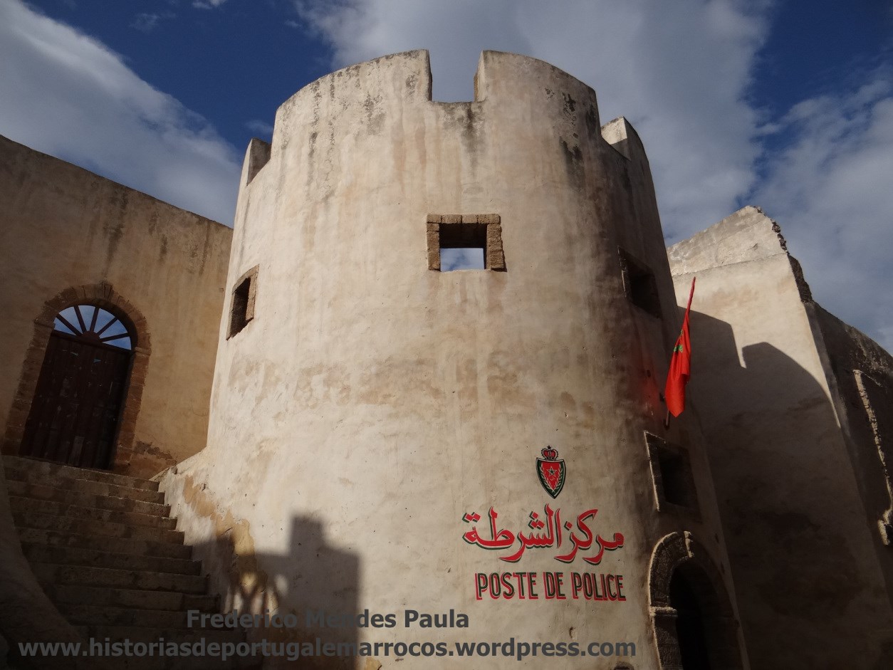 The Torre Boreja at Mazagan — the round El-Brija watchtower that predates the Portuguese. Photo via Histórias de Portugal em Marrocos (2025).
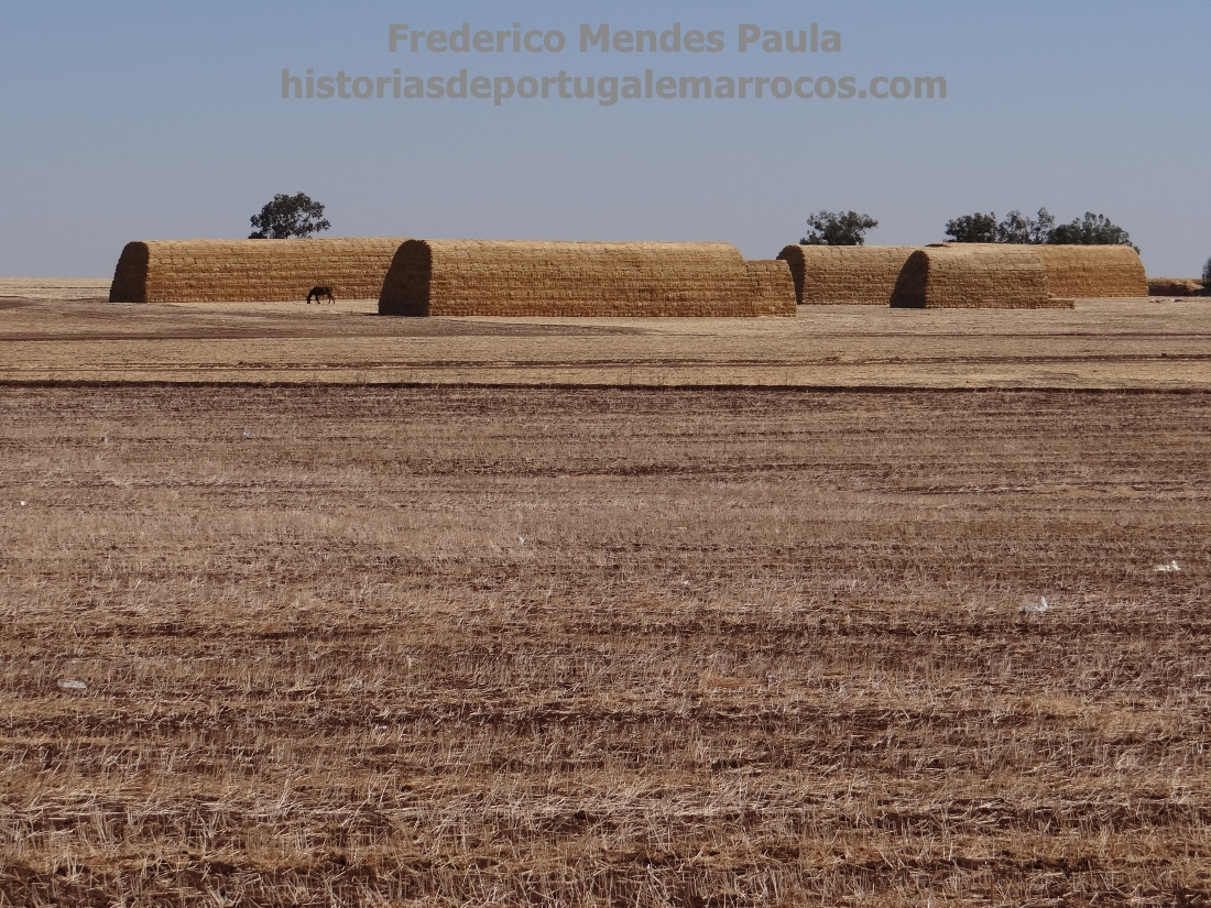 The wheat-rich Doukkala plain behind Mazagan — the economic motive for the settlement. Photo via Histórias de Portugal em Marrocos (2025).
First Portuguese presence (1502–1513)
- 1502 — The Portuguese captain Jorge de Melo, charged by D. Manuel to attack Targa, was caught in a storm in the Strait and put in at Mazagan. According to Pierre de Cénival (Les Sources 1934, I:104), his men sheltered in the ruined, uninhabited Alboreja / El-Bridja (“the small fort”) and he left a small garrison on returning to Lisbon, promising to return. Around the tower there were already some campaign buildings.
- 21 (—) 1505 — D. Manuel authorizes Jorge de Melo, captain of the mounted arquebusiers and son of the alcaide of Castelo de Vide / Évora Vasco Martins de Melo, to build a fortress at Mazagan “at his own cost and expense, with some help we shall grant”, hereditary in his line but safeguarding the Crown’s interest in securing wheat exports (Les Sources 1934, I:108–113). Jorge de Melo never builds it. The fortification Damião de Góis mentions in 1513 — when D. Jaime’s army rested three days at Mazagan en route to Azamor and “adventurous Moors from Azamor came by night to harry our camp … but never dared approach the fort” (Góis, 1566–67, III:XLVI, fl.88) — is certainly the Torre Boreja itself.
- Late summer 1513 — Immediately after D. Jaime’s passage, D. Manuel sends a superintendent with materials for an ephemeral wooden construction — 40 vigas, 440 tábuas and 17,000 nails — “which suggests a first swift timber ‘castelo de pau’” (Moreira 2001:32), perhaps. Some sources place a small square fort with four towers around the old tower as early as 1509 (“Castello Real”), but the established masonry citadel date is 1514.
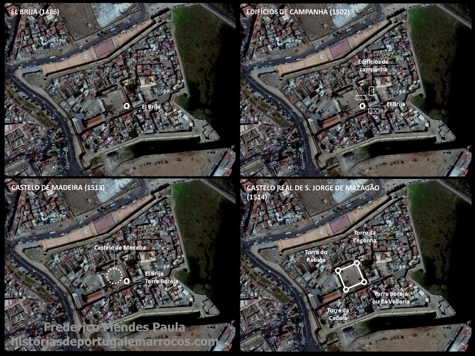 From Torre Boreja to the Castelo Real de São Jorge, 1514 — schematic. Histórias de Portugal em Marrocos (2025).
The Castelo Real de São Jorge (1514)
In 1513, immediately after the Azamor campaign, the Crown decides to build a castle at Mazagan. That year a “castelo de pau” (timber castle) is raised, around which a masonry Castelo Real de São Jorge de Mazagão is built to the design of the master builders Diogo and Francisco de Arruda — with first surveys by the Biscayan military architect Francisco Danzilho (active at Alcácer-Ceguer and Arzila since 1511), who accompanied the Duke of Braganza’s expedition. The finished castle is square, 30 varas a side (≈33 metres), with a ditch and drawbridge and four cylindrical towers at the corners: Cadeia, Rebate (today the mosque’s minaret), Cegonha (later the governor’s house), and Boreja — the last coinciding with the ancient El-Brija (today the Cidadela police post). Construction was run logistically from Azamor and executed with extraordinary speed: it is operational by August 1514 (letter from D. Manuel to Rui Leite sending chapel furnishings, Les Sources 1934, I:598–600). The encircling ditch took four more years — António Leite, 22 July 1518: “as soon as I arrived here I went straight to Azamor to fetch men for this cava which I am now building” (Les Sources 1939, II:202). In the following years timber barracks for the garrison fill the central courtyard (praça de armas) and lean-to buildings are added against the walls outside. A small arrabalde (suburb) forms organically to the northwest, with livestock enclosures, gardens and port installations that make up for Azamor’s poor bar — but daily raids force a barbacã and ditch and a troop of scouts under an adaíl to protect it.
The castle follows the “architecture of the Transition” — the Arrudas’ hallmark: adapting medieval forms to generalized firearms, with characteristic plunging-fire openings (tiro mergulhante) as seen on the Baluarte de São Cristóvão and do Raio at Azamor — identical to Torre Boreja, as a 1917 photo by Joseph Goulven shows before its “reconstruction”.
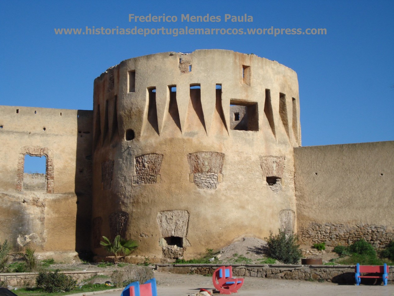 Baluarte de São Cristóvão at Azamor — the Arrudas’ characteristic plunging-fire openings, identical to the original Torre Boreja. Histórias de Portugal em Marrocos (2025).
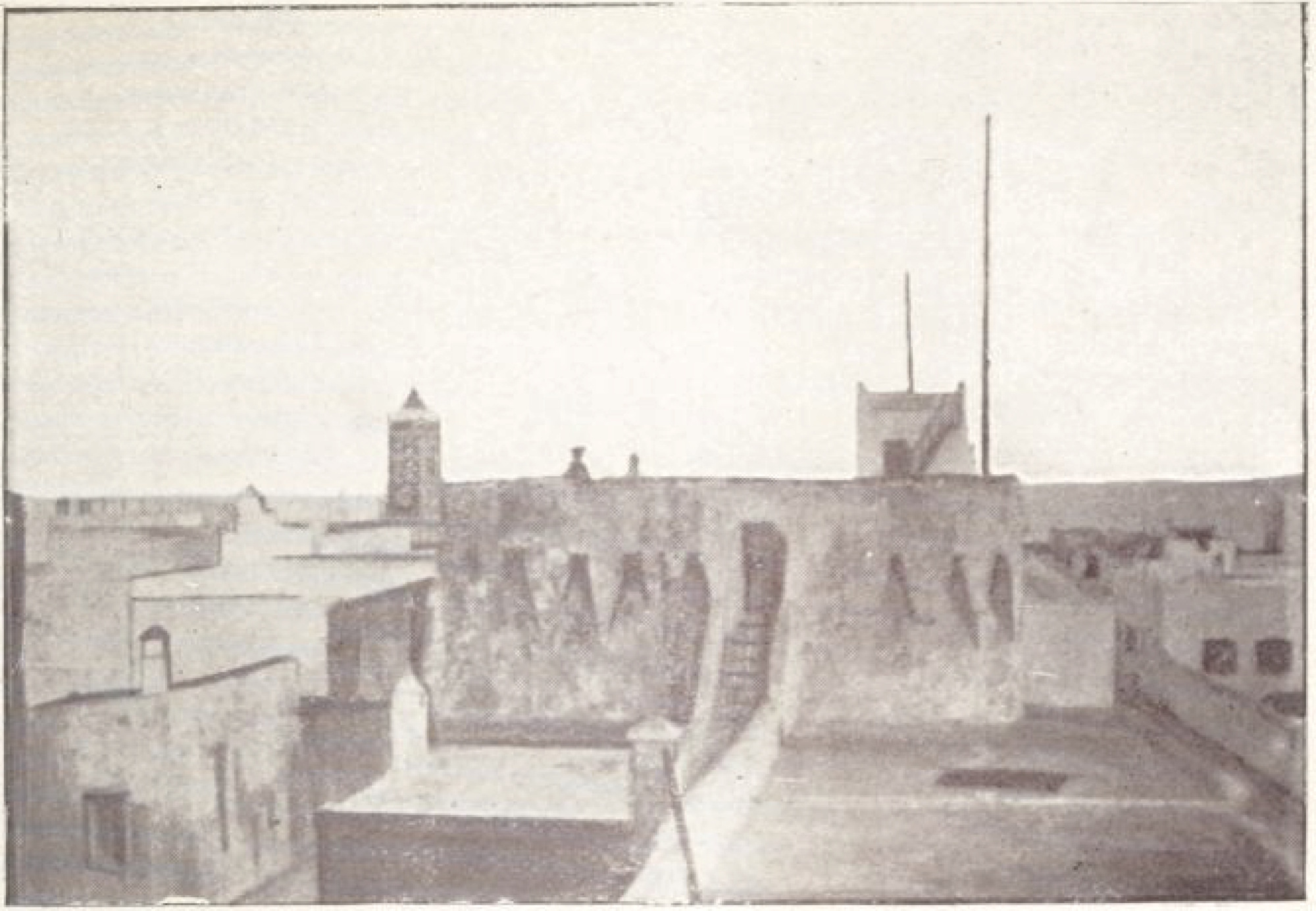 The Torre Boreja photographed by Joseph Goulven in 1917, before its reconstruction. Note the Arruda-style embrasures. Histórias de Portugal em Marrocos (2025).
 Figure 3 — The 1514 Castelo Real: 30 varas (≈33 m) square with four cylindrical towers. (Add plan here.)
The Arrudas — masters of the Transition and the Manueline
The brothers Diogo and Francisco de Arruda were the chief protagonists of this military architecture in southern Morocco — rebuilding Azamor and Safim and raising isolated and urban castles (Castelo do Mar at Safim, Castelo Real at Mazagão, Castelo de Aguz at Souira Kedima). Diogo, stationed in the walls of Naples with Francesco di Giorgio Martini (1485–86) as “Maestro Diego Portoghese” (Correia 2017:152), authored the Baluarte do Paço da Ribeira, Lisbon (1510) and co-designed the Convent of Christ at Tomar; Francisco drew the Tower of Belém (1514) — for most authors the turn to modern military architecture — and Torres Vedras (1516), and with Diogo the castles of Vila Viçosa (1520) and Evoramonte (1532). They arrived in Morocco in 1512 (Diogo to Safim) and reunited in Azamor in 1513 with Francisco’s young son Miguel, who began his apprenticeship on the walls of Azamor and on the Mazagão castle. Miguel de Arruda later became “Mestre das obras dos muros e das fortificações do Reino, Lugares d’Além e Índia” — architect of the Monastery of Batalha (1533) and Graça Church at Évora (1540), then of the great overseas works after 1541: Ceuta, Tangier, Mazagão; São Sebastião at Mozambique and São Salvador at Bahia (1546); São Jorge da Mina, Ghana (1548); on return Forte do Pinhão, Lagos and São Julião da Barra, Lisbon (1553) and the Lagos Walls (1554) — the first modern fortifications built in Portugal itself — whose Stockholm plan (Arquivo Militar de Estocolmo) Rafael Moreira certifies is definitively his hand: “his writing, easily identifiable, is impossible to confuse” (Moreira 2014:213–214).
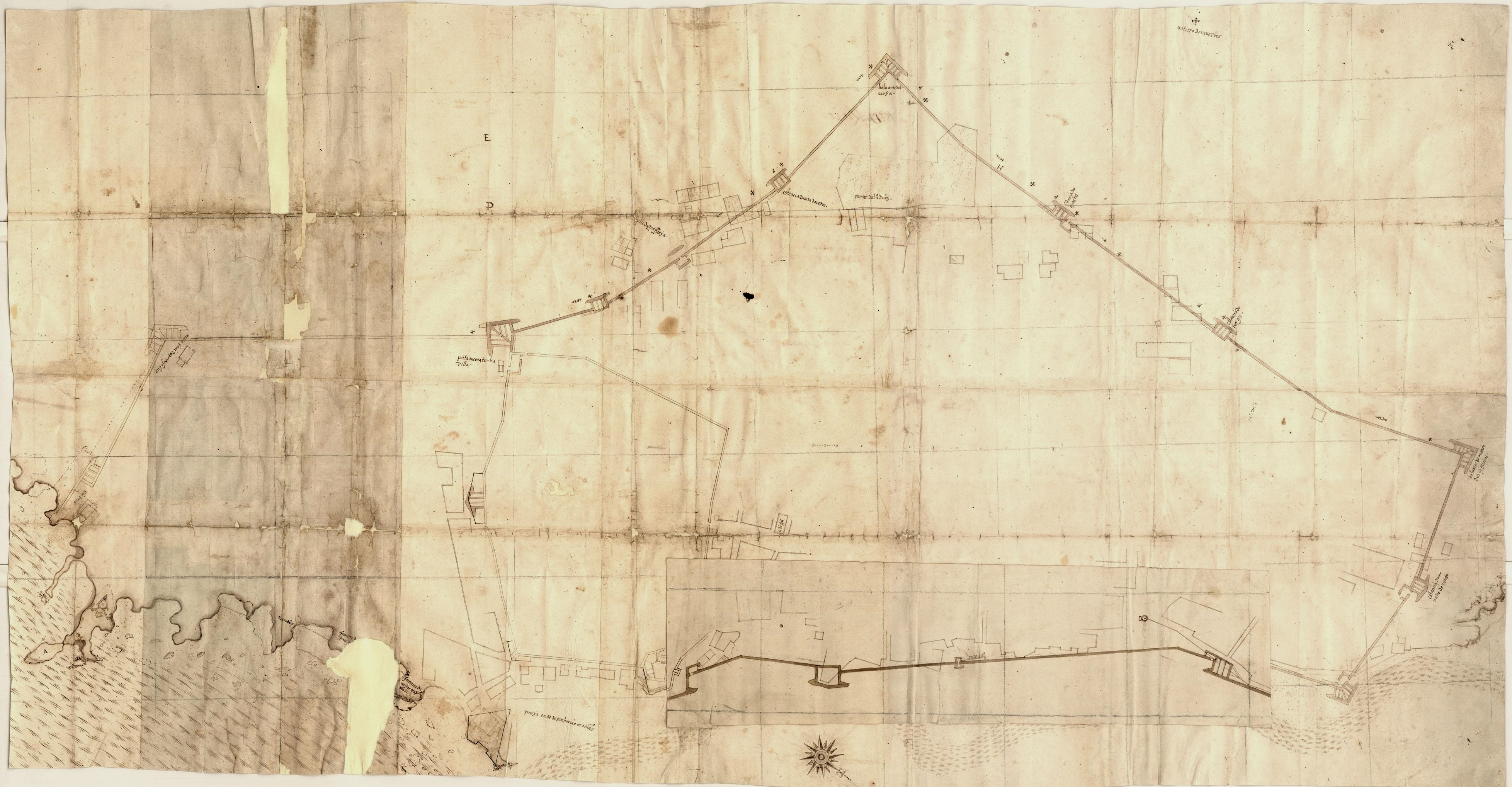 Miguel de Arruda’s project for the Walls of Lagos, 1553–1554 (paper pasted 1557), Arquivo Militar de Estocolmo. Histórias de Portugal em Marrocos (2025).
The Oldest Surviving Plan — the Codex Cadaval (1611)
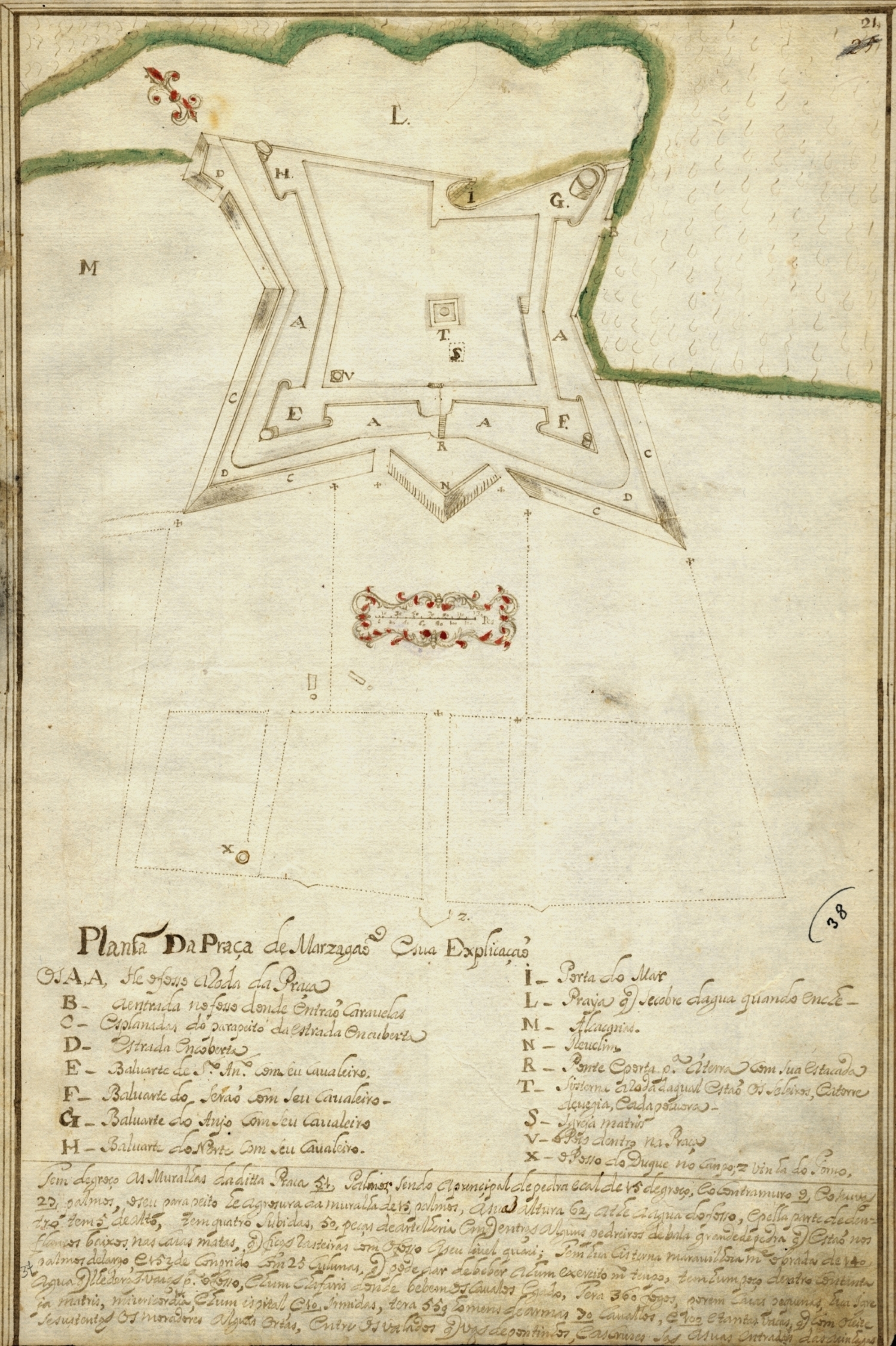
The earliest plan of Mazagan still extant is the “Plan of the Citadel of Mazagan” (1611), preserved in the Codex Cadaval (reference PT-TT-CCDV-29_m0001, IAN — Torre do Tombo, Lisbon). It was drawn up to prepare the works of cleaning the debris from the ditches (the moat). It remains the key cartographic document for the early-17th-century layout of the fortress.
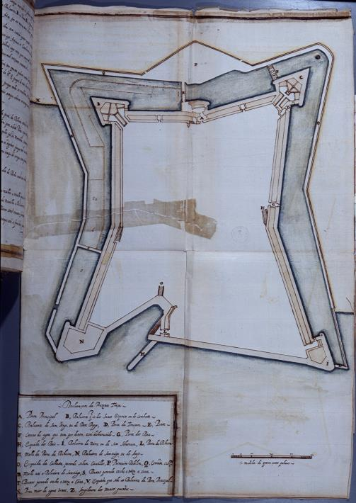 Figure 3b — The oldest surviving plan of Mazagan (1611), Codex Cadaval, Torre do Tombo, Lisbon; drawn to prepare clearance of the moat. (Image supplied by editor.)
The 1534 Debate — to abandon or to fortify?
Long before the superfortress, the Saadian pressure on the southern squares Santa Cruz, Safim and Azamor had forced D. João III in 1534 — after the siege of Safim — to launch a realm-wide consultation: evacuate and abandon, or transform into fortalezas roqueiras (rock-like strongholds)? The answers split the kingdom (Les Sources 1946, II:637–703; 1948, III:4–21):
- Cristóvão de Távora: he who intends to conquer should not release what he holds; roqueiras would be too costly.
- Infante D. Fernando: keep Safim and Azamor; if one must be abandoned, let it be Azamor “for the dangers of its bar in every season.”
- Bishop of Lamego: abandon Santa Cruz, Safim and Azamor, fortify Ceuta and Mazagão.
- Grand-Master of Santiago: abandon all three southern squares, reinforce Ceuta.
- João de Melo Barreto: keep Safim and Azamor at all costs and reinforce them.
- Marquess of Vila Real: raze them and build small roqueiras in their place — “this would not be called abandoning, but atalhar [cutting short], as kings often do with gains from the enemy.”
- Francisco Lobo, Nuno Rodrigues Barreto, D. Rodrigo de Lima, Fernão Vaz de Sampaio, Bishop of Algarve, João Rodrigues de Sá, Aires de Sousa, D. Fradique Manuel — ranging from “launch a crusade on Fez” to “hold everything as is” or “trade Azamor for Salé and the Mamora” (the elder D. Manuel’s plan).
Three arguments recur — finance, the Turkish threat of Barbarossa, and the Duquela’s wheat and strategic weight — but no consensus emerges. The fall of Santa Cruz do Cabo Guer on 12 March 1541 finally precipitates the decision: in October 1541 D. João III orders the evacuation of Safim and Azamor and resolves to build a superfortress at Mazagão on Renaissance principles to concentrate Portugal’s southern Morocco defense.
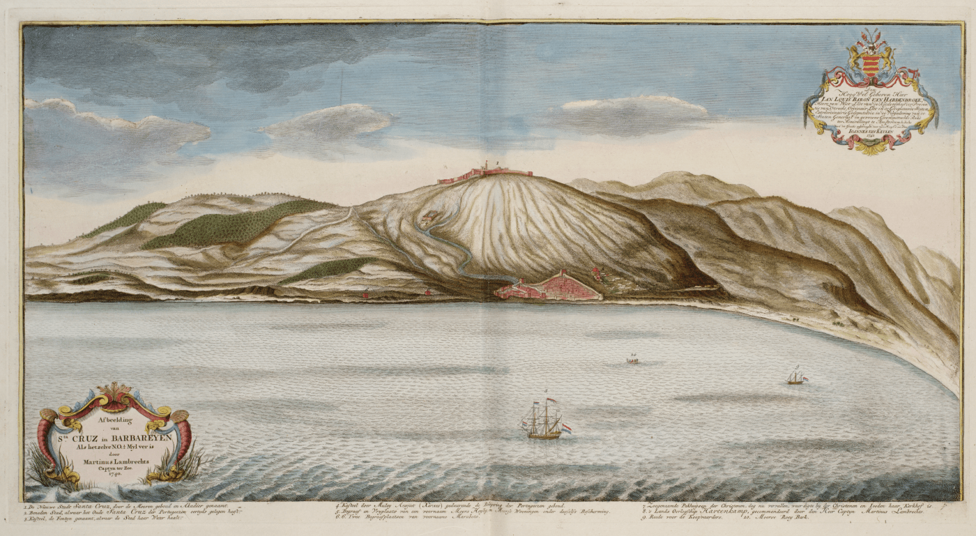 Santa Cruz da Berbéria (Agadir) by Martinus Lambrechts, ca. 1790, Nederlands Scheepvaartmuseum Amsterdam — the 1541 fall that triggered the new strategy. Histórias de Portugal em Marrocos (2025).
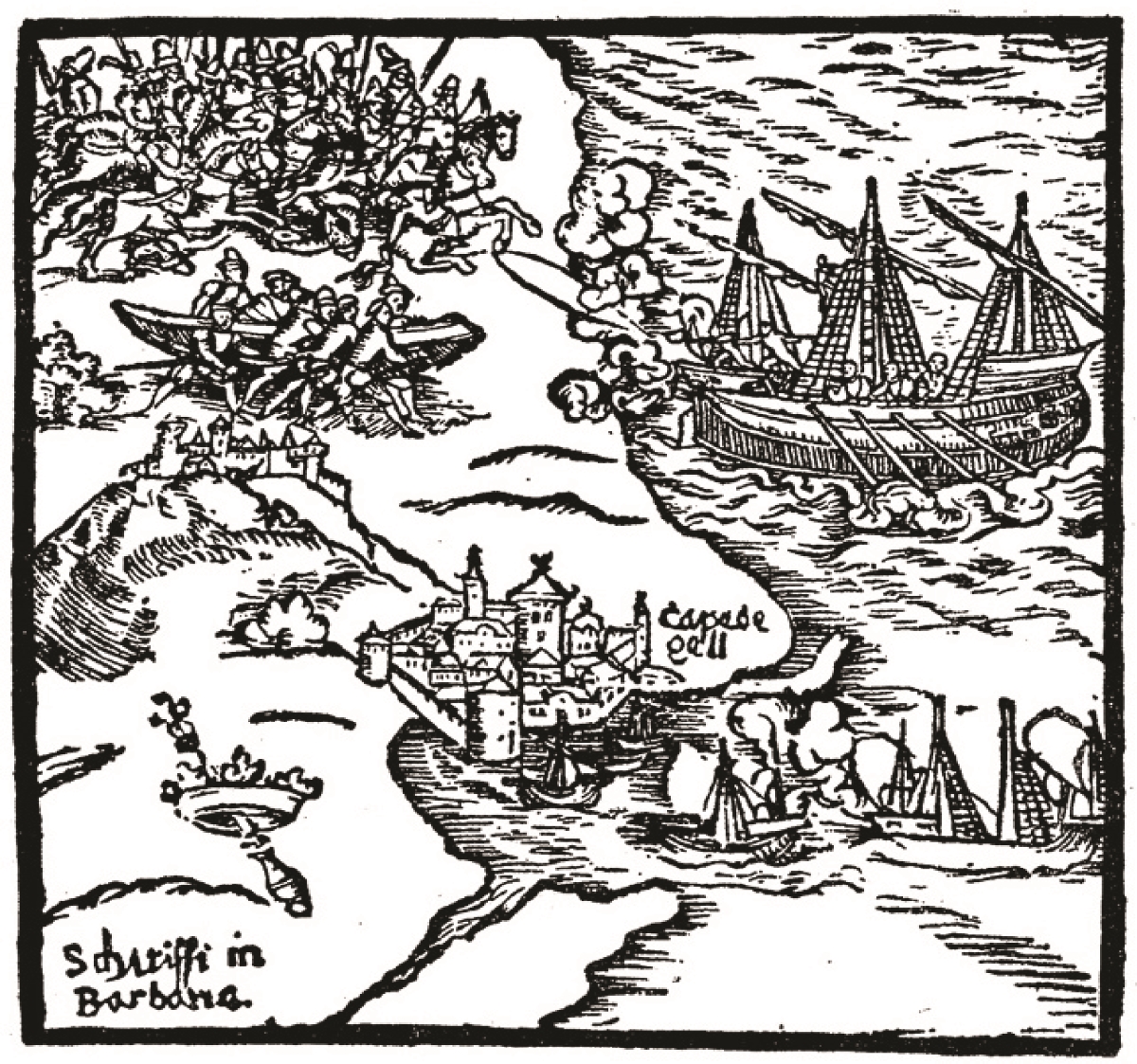 The fall of Cap de Gell (Santa Cruz) as depicted in Hans Staden, Duas Viagens ao Brasil ([1557] 2007).
A citadel built by a team — Holanda, Benedetto, Arruda, Castilho, Torralva, Ribeiro
D. João III entrusts his brother Infante D. Luís with the enterprise, who assembles the most prestigious technicians of the moment:
- Miguel de Arruda — coordinator, fresh from Batalha (1533) and Graça at Évora (1540), soon “Mestre das obras dos muros e das fortificações do Reino, Lugares d’Além e Índia”;
- Benedetto da Ravenna — Italian engineer in the service of Charles V, chief designer;
- Francisco de Holanda — 20 years old, just returned from Italy where he had met Michelangelo and Antonio da Sangallo il Giovane; his mission was officially to draw fortresses — Cobos-Guerra calls him a spy — and he was even arrested while drawing Pésaro “and placed in danger of death for serving the king” (Cobos Guerra 2018:22–23);
- Diogo de Torralva — Miguel’s brother-in-law, for siting studies;
- João de Castilho — sexagenarian Cantabrian, trained on the cathedrals of Burgos and Seville, builder of the Jerónimos, Batalha, Alcobaça and Belém;
- João Ribeiro — site executor with Castilho.
Francisco de Holanda would claim authorship in a letter to D. João III: “the Fortress of Mazagão which was made by my drawing and model, being the first well-fortified force made in Africa, which I drew coming from Italy and France” (Códice, fl.43–44). His drawing is almost identical to the present citadel but for a square of 200 metres a side; according to Jorge Segurado (1961:225) that survives is the schematic plan in the 1727 João Thomás Correa volume (fl.38: “planta esquemática … segundo um códice do século Dezassete de João Tomar Correia … por Affonso de Dornelas”).
 The Holanda-type schematic as preserved in João Thomás Correa, 1727 (BNP). Histórias de Portugal em Marrocos (2025) notes this is the drawing Holanda claimed.
Holanda also complained his advice to build in brick was ignored: small brick laid with little lime in the mortar — “in Italy at that time, brick was used in strong works because, through its little rigidity and weak mortar, it better resisted bombard shots, receiving balls softly and cushioning shock, avoiding splinters” (Segurado 1961:180).
In May 1541 Miguel de Arruda meets Benedetto at the Puerto de Santa Maria (near Cádiz) and together they inspect Ceuta, Tangier, Mazagão, Safim and Azamor. Their conclusion: abandon all southern squares except Ceuta and Tangier and replace the old Mazagão castle with a bastioned fortress “as good as the best in Italy” (Moreira 2001:43).
The next month Miguel returns with Benedetto, bringing Holanda’s approved drawings; at Mazagão they meet Diogo de Torralva and João de Castilho. Torralva’s siting proposal provokes a sharp debate: Castilho objects to exposing the fortress to the heavy autumn-winter swell — but his opinion is outvoted and deemed not to fulfill the royal instructions. Benedetto then enlarges Holanda’s base scheme by one third towards the sea, obeying D. João III’s instruction to Miguel: “quanto esta força mais metida na água fosse, tanto mais forte e defensável será” — the more this force is set into the water, the stronger and more defensible it will be (Várias Cartas, fls.458–459).
Rafael Moreira (2001:52–53) glosses a surviving instruction to Miguel before Benedetto’s second trip — via Torralva, then in Mazagão to choose the best site — as revealing Lisbon’s already extraordinary ambition: a “force” of 50 to 100 braças (=2.2 m) a side or 200 to 400 in perimeter — i.e. almost a kilometre square, with bastions at corners and in the middle if duplication were needed. João III in April 1541 already envisaged realistically — under Holanda and D. Luís — “something enormous — something like a square of almost 200 m a side! — at the chosen site. The engineer’s arrival the following month made that sketch grow by 25 % and changed ideas of the perfect plan.”
For the project itself the drawings are lost; the oldest plan we have is the 1611 Alexandre Massai copy in the Codex Cadaval (Torre do Tombo) already shown, made to report the cleaning of the moat.
The final project that was executed defined:
- A rectangle of about 5.5 hectares (275 × 200 m), its sides broken into a four-pointed star to increase firing angles, with four corner bastions — Santo António (São Jorge / Dom Diogo), Espírito Santo (do Combate / Serrão), São Sebastião (do Norte) and Anjo (Santiago) — plus a fifth Governor’s Bastion protecting the town gate, each crowned by casemates;
- A wall 12 m thick (measured on the built work; later surveys give 10 m at the parapet, 8 m high, 2 m chemin de ronde) carrying the patrol walk;
- A ditch on the south, west and north combined with dikes and buxas (devices to renew water at high tide while preventing drying at low tide);
- A sea front discontinuity forming the small port or calheta, protected by a mole;
- A main town gate (Porta da Vila) central in the west curtain, reached by drawbridge, two sea gates (Porta da Ribeira at the Calheta and Porta da Traição beside Santo António) and a service Porta dos Bois.
 The Renaissance superfortress — structure. Histórias de Portugal em Marrocos (2025) summarizes the 275 × 200 m rectangle, 12 m wall, and five bastions.
How it fought — firing schemes
The pentagonal bastion is the base element, conceived as interlocking parts of a machine to cover every angle. Its wedge shape reduced exposed surface to enemy fire while orillons shielded the rasante (grazing) guns that solved close-range and dead-angle problems. Histórias de Portugal em Marrocos (2025) reproduces contemporary firing diagrams:
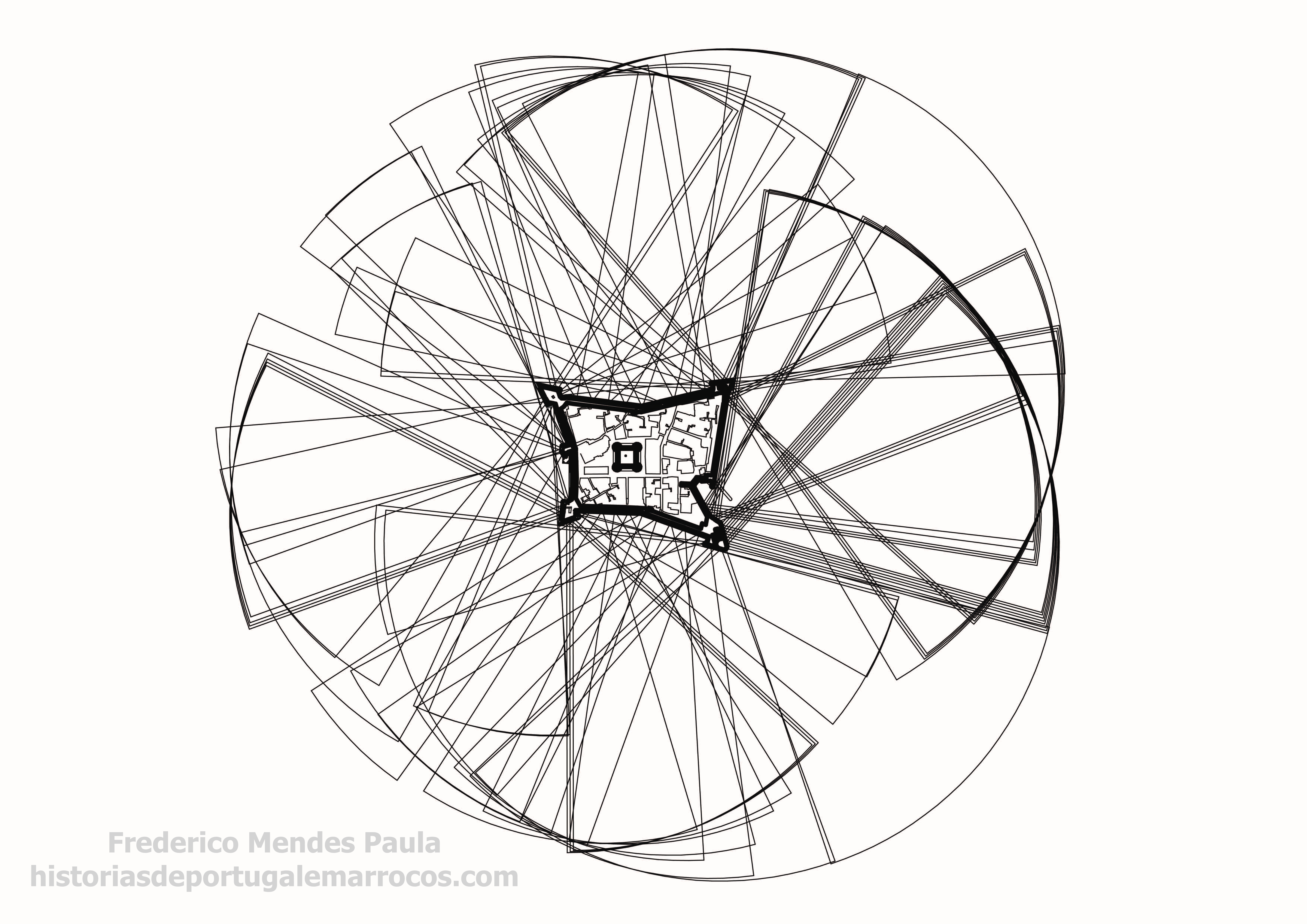 Firing scheme of the Mazagão gun-ports — frontal fire toward land, toward sea, and rasante grazing fire, mean range 600 metres, “as aiming requires.”
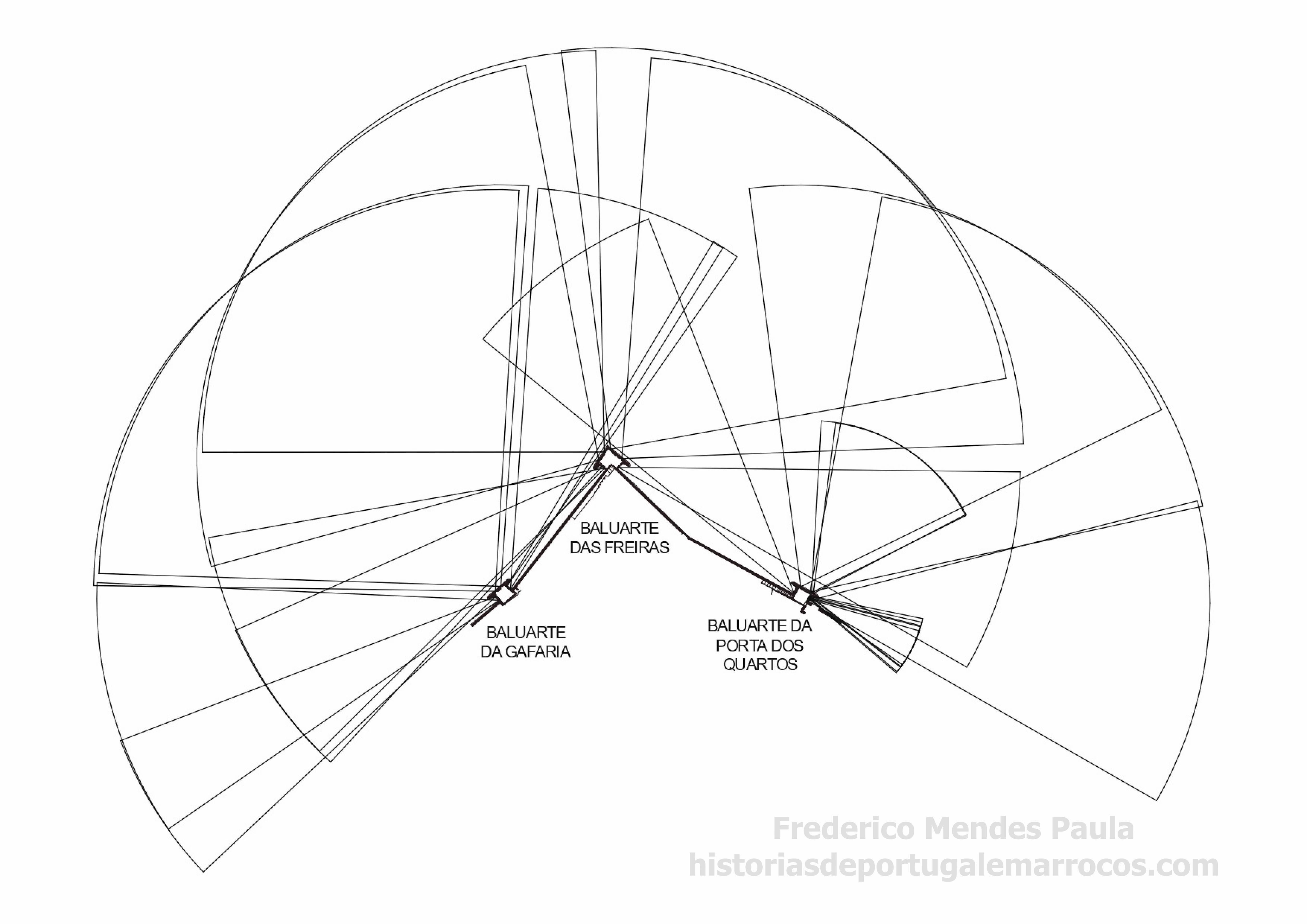 Combined fire from three bastions sweeping the surrounding ground with frontal and grazing fire, abolishing dead angles (shown on the Lagos example).
The cidadela is not an evolution of the Castelo Real but a structure built from scratch that integrates the old castle — entirely remodelled — as its central building. Its defense spilled beyond the ditch: earth terraplenos forming a revelim in front of the Porta da Vila, protected by palisades/tranqueiras, and an esplanada protecting the “estrada coberta” around the ditch.
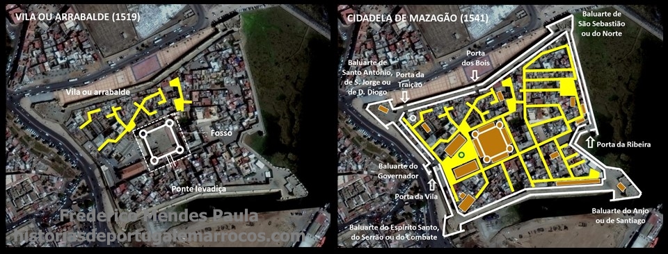 From the spontaneous village to the Cidadela — schematic sequence. Histórias de Portugal em Marrocos (2025).
1552 — a decade after the Cidadela
By 1552 the Cidadela had stood for a full decade. Its land front (Frente de Terra) inaugurated in August 1541 and sea front completed in 1542 had weathered ten Atlantic winters; the cistern (finished Nov 1547, 2,500 m³) had supplied five annual cycles; the 38-hectare Campo Exterior Consolidado, subdivided by valos and gated by tranqueiras in 1541–42, was in full annual rotation — wheat and barley, vines and fava — with the daily segurar o campo routine already described by later witnesses. Under Governor Álvaro de Carvalho (1551–1561) and within the EVE captaincy sequence, the garrison — roughly 400–500 men in the 1550s on the trajectory toward Mesquita’s 150 horse/400 foot in 1751 — maintained the five bastions, 69 embrasures, twin buxas and covered way in routine repair; the calheta harbour between the Angel bastion and the sea curtain received Biscayan wheat ships as it had since 1486. Outside, the Saadian sultanate, unified under Mohammed al-Shaykh since 1549, had taken Fez in 1549 and was pressing toward the Sahara, but Mazagão itself saw no general siege that year — the next great test would be 1554 (loss of Fez to the Saadians’ final consolidation) and 1562. In the town, the Rua da Carreira and Rua Direita grid was now fully built up: the Porta da Vila–Terreiro–Matriz axis functioned, the Castelo Real’s central courtyard housed the Vedoria, Misericórdia hospital, jail and granaries, and the outer arrabalde’s organic nucleus to the northwest persisted as a memory beneath the Renaissance order. Architecturally, 1552 thus captures the Cidadela at equilibrium — no longer a building site, not yet a besieged icon — its Renaissance trace, battered scarp, orillon-protected flanks and wet ditch all measurable as built.
Building it — July 1541 to 1542
Works start in July 1541 when João de Castilho returns with an army of 1,500 masons recruited at Évora, Tomar and Torres Novas; in August the Cidadela is inaugurated with only the land front (Frente de Terra) built. The following year the sea front (Frente de Mar) is finished. Castilho’s labour — who told D. João III “nela amanheço e nela anoiteço” (in it I dawn and in it I dusk) and whom João Ribeiro called “a man capable of building the world alone” (Moreira 2001:48–49) — was tireless. Now sexagenarian, Cantabrian-trained at Burgos and Seville, he had built the Jerónimos, Batalha, Alcobaça and Tomar. Stone was quarried northwest of the site, its extraction and transport requiring strong military escort, with an armada permanently offshore defending the harbour. Many decisions were made on site — e.g. the Couraça at the Calheta: Luís de Loureiro, December 1542, writes to the King that the calheta is useless — “from half high tide onward the water beats so hard on the bastion that no boat can enter” — and officials propose a northern couraça entering the sea at low tide to calm that water (Les Sources 1951, IV:116).
The Great Siege of 1562
Mazagan endured nine sieges during the Portuguese period. The most famous — and one of the hardest-fought — was the Great Siege of Mazagan (1562), fought 18 February – 7 May 1562, part of the Moroccan–Portuguese conflicts.
After Morocco was unified under Mohammed al-Shaykh (1549) and his son Abdallah al-Ghalib (from 1557), the Saadians targeted the fortified Portuguese city. Preparations ran through 1560–61. The Portuguese governor Álvaro de Carvalho was in Lisbon; his deputy Rui de Sousa de Carvalho sent a spy to Fez to confirm the Sultan’s preparations, then dispatched a ship with a distress call to Regent Dona Catarina. When the qaid of Azemmour arrived on 18 February 1562 and demanded surrender via an alfaqueque (negotiator of captives), Rui de Sousa de Carvalho replied: “May he come as fast as he can, because I had been waiting for him in this fortress with plenty of quinces, pears and pomegranates and other such fruits which were not lacking in this fortress.”
The besieging army of Abu Abdallah Mohammed II Saadi numbered 85,000–120,000 men with 24 cannon (some Portuguese estimates ran even higher); the garrison mustered only about 2,800 soldiers. Relief poured in from Portugal in a wave of patriotic volunteers. Though bombardment and assaults pounded the defenses, the fortress held — its 69 gun embrasures and seawater moat (kept full at low tide by locks) doing their work — and the besiegers withdrew on 1 May after roughly two and a half months.
Casualties (per Wikipedia): ~117 Portuguese killed and 270 wounded; over 25,000 Moroccans killed.
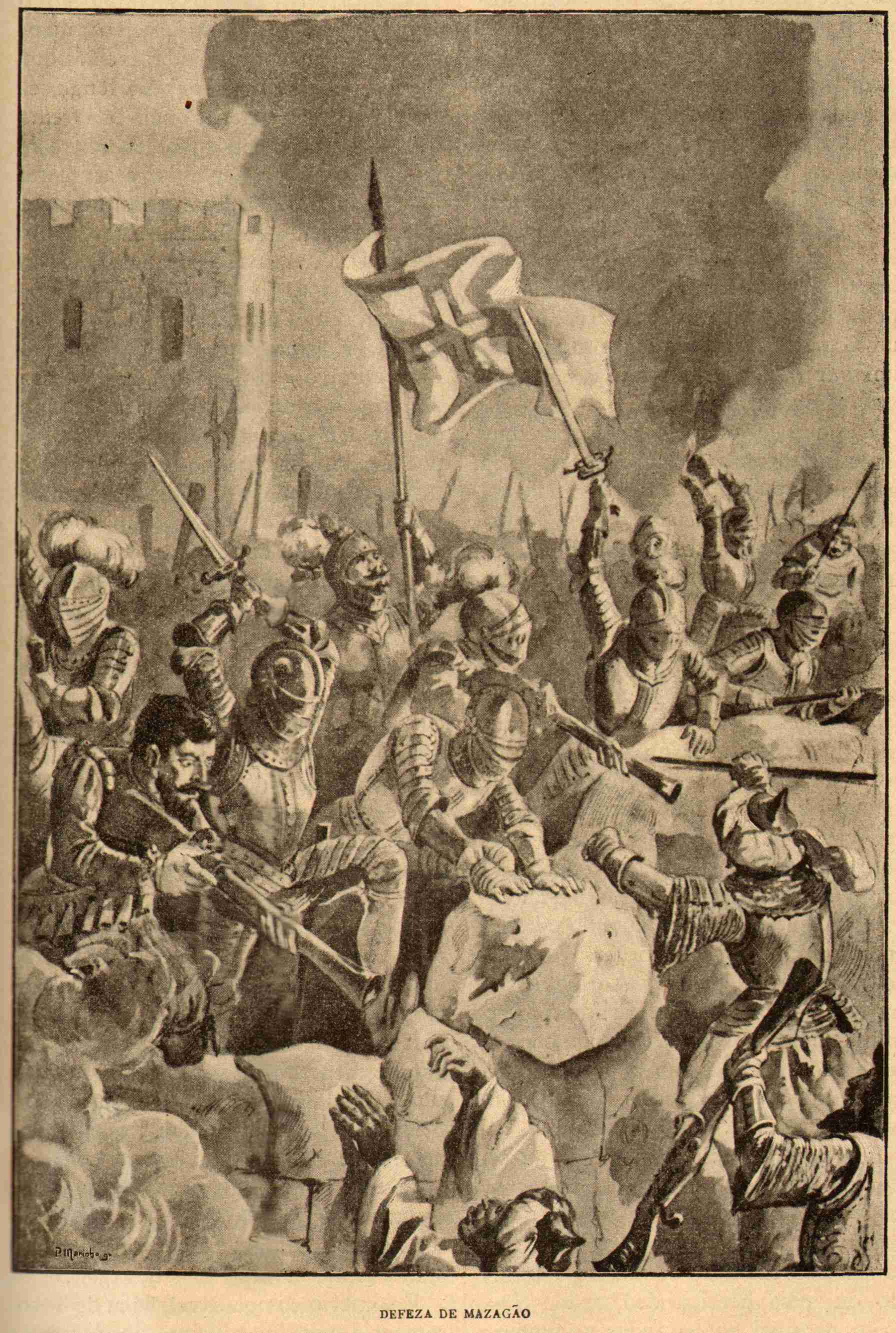 Figure — “Defesa de Mazagão”, illustration by Alfredo Roque Gameiro in História de Portugal, Popular e Ilustrada, vol. 4 (Wikimedia Commons, public domain).
The Final Siege and Evacuation (1769)
By the late 18th century Mazagan was the last Portuguese possession in Morocco. In early 1769, the Alawite Sultan Sidi Mohammed ben Abdallah — refusing to accept Portuguese rule — arrived with an army reported at 70,000 men and 35 cannons, bombarding the city. The garrison numbered only 592 men (472 infantry, 99 cavalry, 21 gunners).
Under orders from King José I (advised by the Marquis of Pombal), the Portuguese agreed to evacuate, taking everyone — but leaving everything behind. In the three days before departure they burned furniture, killed livestock, and mined the bastions and main entrance (reportedly ~40 barrels of gunpowder per bastion). Evacuation was completed on 11 March 1769. When the Moroccans entered, the explosion — said to have been triggered by a man left behind (“Pedro”) — devastated the Governor’s Bastion and a large stretch of the main rampart, killing thousands.
The citadel then stood uninhabited for nearly half a century and was called al-Mahdouma (“the Demolished/Ruined”). About 2,000 inhabitants were transported to Brazil, where they founded Nova Mazagão (today Mazagão Velho, Amapá).
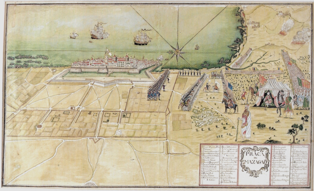
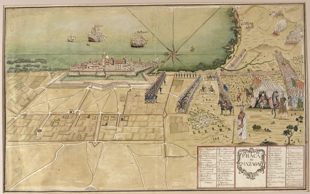 Figure 4 — “Praça de Mazagão” (Wikimedia Commons File:Praça de Mazagão.jpg, unknown 18th-century author, public domain, via históriasdeportugalemarrocos.com). The image is the lead illustration on the Wikipedia “Siege of Mazagan (1769)” page — captioned “The siege and the evacuation of Mazagan in 1769” — and shows not just the star enceinte itself but the Moroccan forces stationed around it to liberate it: tribal camps and the besieging army of Sultan Mohammed ben Abdallah (70,000 men, 35 cannon) encircling the last Portuguese square in Morocco, held by only 592 defenders, in early 1769. The view captures the siege’s geography at a glance — the five bastions, moat, and harbour bay under blockade from the land side.
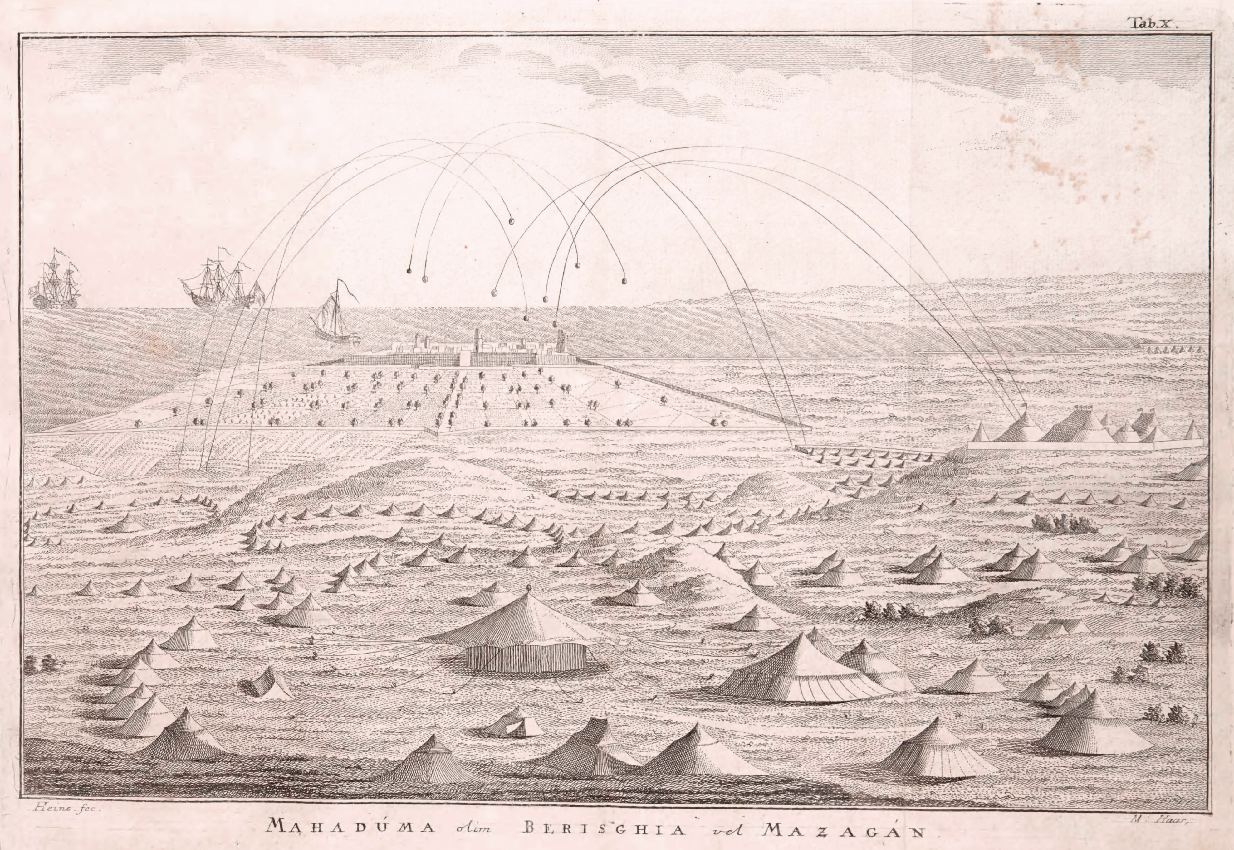 Figure 4b — Engraving by Peter Haas showing the Siege of Mazagan of 1769, as included in Georg Hjersing Høst’s “Efterretninger om Marokos og Fes” (1779). Titled “Mahadúma Berisghia Mazagán”, the plate depicts the fortress under bombardment from the Moroccan lines. Like the Praça view above, it is the second illustration used on the Wikipedia Siege of Mazagan (1769) article (public domain, Wikimedia Commons File:Mahadúma Berisghia Mazagán.jpg, 1779, via archive.org/details/HoestEfterretninger1779).
Revival as El Jadida (19th century)
- In the mid-19th century, Sultan Moulay Abderrahman ordered the Pasha to rebuild the destroyed portions of the fortification (in a style slightly different from the original), build a mosque, and rehabilitate the city.
- The name Mazagan was banned; from 1820/1821 the city was called El Jadida (“the New”). The minaret of the new mosque was built over the old Torre de Rebate, symbolizing continuity.
- A multicultural community of Muslims, Jews, and Christians (European merchants, missionaries, ambassadors) grew; synagogues and a Spanish church were added. Under the French Protectorate the quarter was labelled the “Cité Portugaise”, the moat was filled in, and a new gate opened onto the Rua da Carreira.
- In 2004 the Portuguese City of Mazagan was inscribed on the UNESCO World Heritage List. Today ~3,700 people live inside the Portuguese city.
Captains and Governors of Mazagan (1514–1769)
Complete chronological list of the Portuguese captains and governors who commanded Mazagan from foundation to evacuation. Compiled from the Encyclopaedia of Portuguese Expansion (EVE) — CHAM / NOVA FCSH (CC BY 4.0) — which cites A. H. de Oliveira Marques, História de Portugal (1984).
Abbreviations: d.n. = de novo (re-appointed, second or third term); (Provisional) = interim command; brackets [ ] and … = uncertain or incomplete dates in the source record.
| Tenure | Captain / Governor |
|---|---|
| 1514–1517 | Martim Afonso de Melo |
| 1517–1529 | António Leite |
| […] – […] | […] (gap in the record) |
| [1536]–[1537] | Manuel de Sande |
| [1539] | António Leite, d.n. |
| [1539]–1541 | João Gomes |
| 1541–1548 | Luís de Loureiro |
| 1548–1551 | Tristão de Ataíde |
| 1551–1561 | Álvaro de Carvalho |
| 1561–1562 | Rui de Sousa de Carvalho |
| 1562 | Álvaro de Carvalho, d.n. |
| 1562 | Rui de Sousa de Carvalho, d.n. |
| 1562–1564 | Francisco de Barros de Paiva |
| 1564–1572 | Rui de Sousa de Carvalho, d.n. |
| 1572–1574 | Pedro Álvares de Carvalho |
| 1574 | Bernardim de Carvalho |
| 1574–1577 | Gil Fernandes de Carvalho |
| 1577–1578 | Francisco de Figueiredo (Provisional) |
| 1578 | Martim Correia da Silva |
| 1578–1581 | João de Mendonça Furtado |
| 1581–1582 | Pêro de Mendonça Furtado |
| 1582–1586 | Francisco de Mendonça Furtado |
| 1586 | Gil Fernandes de Carvalho |
| 1586–1607 | Diogo Lopes de Carvalho |
| 1607–1610 | D. Manuel Mascarenhas |
| 1610–1615 | Henrique Correia da Silva |
| 1615–1619 | D. Jorge Mascarenhas |
| 1619–1624 | Brás Teles de Meneses |
| 1624–1627 | D. Gonçalo Coutinho |
| 1627–1631 | D. Francisco de Almeida |
| 1631–1635 | João da Silva Telo de Meneses |
| 1635–1640 | D. Francisco de Mascarenhas |
| 1640 | D. Luísa Antónia de Velasco e Nuno da Cunha da Costa |
| 1640–1642 | Martim Correia da Silva (Provisional, then confirmed) |
| 1642–1645 | Rui de Moura Teles |
| 1645–1648 | D. João Luís de Vasconcelos e Meneses |
| 1648 | Gonçalo Barreto, António Dinis Barbosa e Gaspar Rodrigues (Provisionals) |
| 1648–1649 | Nuno da Cunha da Costa, d.n. |
| 1649 | D. Francisco de Noronha |
| 1649–1650 | Nuno da Cunha da Costa, d.n. |
| 1650–1654 | D. Francisco de Noronha, d.n. |
| 1654–1658 | Alexandre de Sousa Freire |
| 1658–1661 | Francisco de Mendonça Furtado |
| 1661–1667 | Cristóvão de Melo |
| 1667–1671 | D. Martinho Mascarenhas |
| 1671–1677 | D. Marco de Noronha |
| 1677–1681 | Cristóvão de Almada |
| 1681–1687 | Bernardim de Sousa de Távora Tavares |
| 1687–1691 | Manuel de Sousa de Castro |
| 1691–1692 | Domingos de Matos |
| 1692–1695 | João de Saldanha de Albuquerque |
| 1695–1698 | Luís de Saldanha da Gama |
| 1698–1702 | D. Sancho de Faro e Sousa |
| 1702–1705 | Manuel de Sousa Tavares de Távora |
| 1705–1713 | Francisco de Melo e Castro |
| 1713–1719 | D. Manuel Rolim de Moura |
| 1719–1724 | Duarte Sodré Pereira |
| 1724 | António José de Miranda Henriques |
| 1724–1734 | João Jacques de Magalhães |
| 1734–1745 | Bernardo Pereira de Berredo |
| 1745–1752 | D. António Álvares da Cunha |
| 1752–1757 | José Leite de Sousa |
| 1757–1763 | D. José Joaquim Vasques da Cunha |
| 1763–1769 | D. Dinis Gregório de Melo e Castro Mendonça — last governor; oversaw the 1769 evacuation |
Source: Encyclopaedia of Portuguese Expansion (EVE), CHAM – NOVA FCSH / UAc, “Mazagan: Captains and Governors (1514–1769)” (2009), https://eve.fcsh.unl.pt/en/lists/mazagan-captains-and-governors-1514-1769 (CC BY 4.0). Bibliography cited therein: A. H. de Oliveira Marques, História de Portugal (1984).
The Fortification in Detail
Walls & Ramparts — built section
The ramparts are massive, slightly battered (inclined) walls forming a continuous enceinte. All dimensions below are taken from the built work, the 1611 Codex Cadaval legend (keys A–Z), and the 2025 synthesis (Les Sources / Moreira):
- Overall footprint: rectangle ~275 m × 200 m (5.5 ha), broken into a four-pointed star by angling the curtains outward from the diagonals of the 1514 Castelo Real. Star extents are commonly given as ~250 m × 300 m tip-to-tip (the longer axis runs NW–SE along the coast).
- Height: ~8 m average from outer foot to parapet coping; parapet adds ~1.5–1.8 m above the chemin de ronde.
- Thickness at base: ~12 m (2025 measured on the built work). Thickness at parapet: ~10 m (HPIP/UNESCO surveys). The wall is an earth-filled embankment (embanque) faced in coursed limestone masonry; fill is compacted earth and rubble.
- Batter: gentle outward incline (~5–8°) improving resistance to bombardment; the outer face is dressed stone, inner face rubble.
- Chemin de ronde: a 2 m-wide peripheral patrol passage enclosed within the wall mass, ventilated by narrow slits and accessed by stone staircases at each bastion (keys H, O, V on the 1611 legend).
- Sea-side curtain: lighter construction — rampart ~6 m wide — because it faces the sheltered calheta (small harbour) rather than heavy land artillery; it includes a deliberate discontinuity to form the harbour, protected by a mole (molhe, keys M,R).
- Exterior accessories: dikes and buxas (keys S,T) — gated culverts that renew seawater at high tide and retain it at low tide, keeping the ditch wet; estrada coberta (covered way, key Q) around the outer lip of the ditch; terraplenos forming a revelim in front of the Porta da Vila, screened by palisades/tranqueiras; esplanada beyond.
 Figure 5 — Rampart section: 8 m high, 12 m at base / 10 m at parapet, 2 m chemin de ronde enclosed. Sea curtain 6 m.
Overall Geometry — for reconstruction
| Element | Dimension / Position |
|---|---|
| Inner rectangle (Cidadela) | 275 × 200 m, long side roughly parallel to coast, short side inland |
| Star extents (bastion tips) | ~300 × 250 m |
| Castelo Real inside (1514) | 30 varas square = 33 m side, walls centred; its four corner towers become the citadel’s core (later Cadeia / Rebate / Cegonha / Boreja) |
| Curtain wall segments | 4 main curtains (north, east, south, west) plus 2 short sea curtains flanking the calheta; each curtain inflected 8–12° outward to bring bastion flanks into crossfire |
| Parapet | ~1.6 m high above chemin de ronde, with 69 embrasures total in 1562 (evenly divided: ~14 per bastion/curtain) |
| Ditch (cava) | ~20 m wide × 3 m deep, continuous on south, west and north; open to sea on the east via the calheta and the two buxas |
| Covered way | ~4–5 m wide around outer ditch edge, with glacis |
| Harbour (calheta) | small square basin ~40 × 40 m formed by the sea curtain gap and the two moles; reached via Porta da Ribeira (L) and Escada da Calheta (O) where horses ascended |
All curtains are straight in plan between bastions; the star’s points are not regular — the land front is the longest and most strongly bastioned, the sea front the shortest.
The Five Bastions — pentagonal, interlocking
The fortress is defined by five large bastions at the angles of the irregular quadrilateral, linked by long inflected curtains and surrounded by the moat. Four survive; the fifth (Governor’s) was mined in 1769 and is in ruins. All are pentagonal (wedge) bastions conceived as interlocking gun platforms — each covering the adjacent curtains with frontal and grazing (rasante) fire at ~600 m mean range (diagrams in the 2025 article). Typical reconstructed footprints from the 1611/1727/1757/1802 plans (±1–2 m tolerance for drawing):
- Face length: 18–22 m each
- Flank length: 12–15 m, set back behind a curving orillon (radius ~4–5 m) shielding the flank embrasure
- Gorge (rear) width: ~25–28 m where the bastion meets the curtain
- Height: 8 m to platform, parapet +1.6 m; platform beaten earth, in places two-tiered (lower platform slightly above the curtain, upper with embrasures)
- Point angle: 60–70° (beak), with a slightly rounded cornerstone on St Sebastian preserving the original profile
| Bastion | Position & Orientation | Plan shape & Dimensions | Key features | Condition |
|---|---|---|---|---|
| Angel (Santiago / do Anjo) | East, into the sea (344°), tip in water | Single flank west only; one curved orillon + round turret Ø 3.5 m with 3 crevices; lower casemated embrasure (now walled) facing the ditch. Platform ~28 × 22 m. | Shelters the calheta harbour; sea curtain’s mole (R) ties to its shoulder. | ✅ best preserved |
| St Sebastian (do Norte) | North (0°) | Beak-shaped point with orillon and rounded cornerstone — the only one preserving the original beak; single flank west, curving orillon + turret + lower embrasure; interior powder magazine and chapel of St Sebastian inside the bastion mass. Platform ~30 × 24 m. | Beak point 65° | ✅ |
| St Antoine (Santo António / Dom Diogo) | West (270°), land front | Beak-shaped point, two flanks each with curved orillon + turret; two lower bunkers connected by passage, embrasures to both flanks. Linked to Traitor’s Gate (Porta da Traição, D). Platform ~32 × 26 m. | Two-flank bastion, strongest on land front | ✅ altered |
| Holy Ghost (Espírito Santo / Serrão / Combate) | South (185°) | Beak-shaped point, two curved orillons; raised platform reached by central axial ramp; two independent lower bunkers (ruined). Platform ~30 × 24 m. | B is its curtain bastion (key B) | ✅ severely altered |
| Governor (do Governador / Nossa Senhora) | Centre of south (land) curtain, straddling the main entrance | Guards the Porta da Vila (A); lower embrasure over the ditch, compartment before the courtyard, central ramp to platform, orillon + turret. Platform ~28 × 22 m before destruction. | Mined with ~40 barrels per bastion in 1769; explosion destroyed its curtain | ❌ ruins, scarp trace visible |
All bastions carry a small vaulted powder magazine for wartime service and casemated lower bunkers with ventilating ceiling oculi opening over the moat. Upper platforms retain colonial bronze cannons today.
 Figure 6 — Bastion of the Angel. (Add image here.)
 Figure 7 — Bastion of St Sebastian. (Add image here.)
 Figure 8 — Bastion of St Antoine. (Add image here.)
 Figure 9 — Bastion of the Holy Ghost. (Add image here.)
 Figure 10 — Governor’s Bastion ruins. (Add image here.)
Common bastion internals (per HPIP / Portuguese heritage records):
- Beaten-earth platforms (some with two platform levels — one slightly above the rampart, one higher with the embrasures).
- Curved orillons headed by a turret (probably brick-vaulted) with crevices for surveillance and fire.
- Bunkers at a lower level with embrasures opening over the moat (ventilated through ceiling openings).
- A small powder magazine in each bastion for wartime use.
- Numerous colonial Portuguese cannons still sit on the bastion tops today.
Period Plans & Bastion Details
The following plates are reproduced from João Campos, O modelo italianizante no sul de Portugal: o castelo de Vila Viçosa e Mazagan (Figs. 10–16). They record the fortress and its bastions as shown in period plans — notably the long-lost Governor’s Bastion (Fig. 12), destroyed by the Portuguese when they evacuated in 1769. (Image-to-figure pairing follows the PDF’s figure list; please verify visually.)
Overall Plans
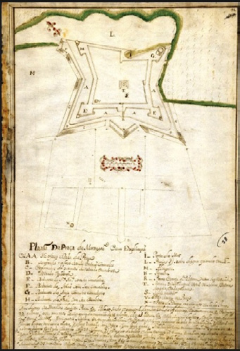 Figure — Fig. 10 (a): Praça-Forte de Mazagão, João Thomas Correa, Livro de várias plantas deste Reino e de Castela. (Verify.)
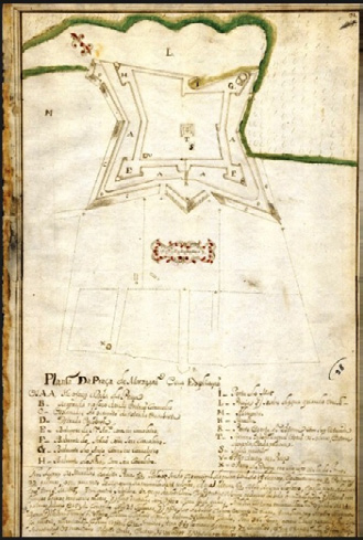 Figure — Fig. 10 (b): detail of the Correa plan of Mazagan. (Verify.)
 Figure — Fig. 11: Plan of the city and fortress of Mazagan by António Inácio da Silva, c. 1802. (Verify.)
Bastion Details
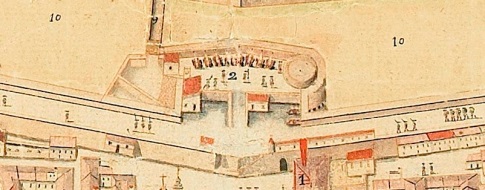 Figure — Fig. 12: the Governor’s Bastion (baluarte do lado da terra), showing the lower embrasure directed toward the Bastion of Santo António. Mined and destroyed by the Portuguese in 1769. (Verify.)
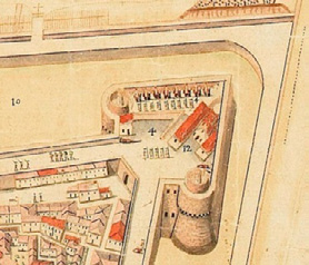 Figure — Fig. 13: Bastion of Santo António, from the 1802 Silva plan. (Verify.)
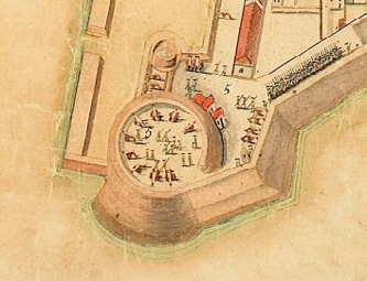 Figure — Fig. 14: Bastion of S. Sebastião (or do Anjo), with its beak-shaped flanked angle and rounded cornerstone. (Verify.)
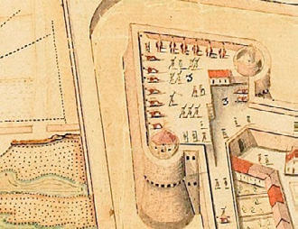 Figure — Fig. 15: Bastion of the Espírito Santo. (Verify.)
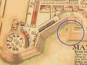 Figure — Fig. 16: detail of the Porta do Mar (Sea Gate), from the 1802 Silva plan. (Verify.)
Ancient Plans Gallery — Mazagão (1611–1916)
All plans below are harvested from Histórias de Portugal em Marrocos — “Plantas de Mazagão” (https://historiasdeportugalemarrocos.com/mazagao/, blog of Frederico Mendes Paula) — which gathers public-domain scans from the Arquivo Nacional da Torre do Tombo, Biblioteca Nacional de Portugal, Bibliothèque nationale de France, Direção-Geral do Território, Casa de Ínsua, and Gabinete de Estudos Arqueológicos da Engenharia Militar. Individual archive credits are given per plan. This gallery completes the cartographic sequence from the earliest Codex Cadaval plan (1611) through the French Protectorate town extension (1916).
1611 — The Codex Cadaval (Torre do Tombo)
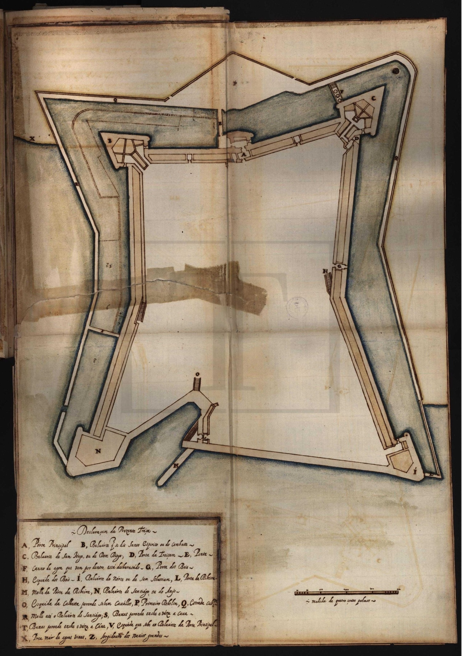 1611 — Planta da Cidadela de Mazagão, anonymous, in “Descrição e plantas da costa, dos castelos e fortalezas, desde o reino do Algarve até Cascais, da ilha Terceira, da praça de Mazagão …” — Casa de Cadaval, n.º 29, PT/TT/CCDV/29, Arquivo Nacional da Torre do Tombo (via Histórias de Portugal em Marrocos). The earliest surviving plan of Mazagan; drawn to prepare the works of cleaning the debris from the ditches (cava) that was clogged with silt and sand. The blog notes the set was offered to D. João IV by Frei Luís da Natividade and includes sheets by Alexandre Massai (some attributed to Leonardo Torriano and Filipe Terzio). This copy is also held as our Figure 3b.
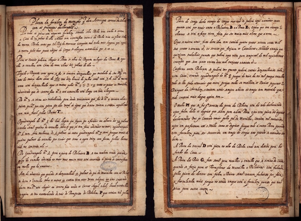 Detail — Legend for the 1611 plan as transcribed on the blog: A Porta Principal; B Baluarte Santo Espírito / do Combate; C Baluarte São Jorge / de Dom Diogo; D Porta da Traição; E Ponte; F Cano de água; G Porta dos Bois; H Escada dos Bois; I Baluarte do Norte / São Sebastião; L Porta da Ribeira; M Molhe da Porta da Ribeira; N Baluarte de Santiago / do Anjo; O Escada da Calheta; P Primeiro Revelim; Q Estrada coberta; R Molhe até ao Baluarte de Santiago; S/T Buxas por onde enche e vaza a cava; V Escada ao Baluarte da Porta Principal; X Praia mar de águas vivas; Z Sorgidouro dos navios grandes. Titled “planta da Fortaleza de Mazagão que deu Henrique Correia da Silva com as presentes declarações” (clearing of the cava ordered by the King).
1720–1760 — Simão dos Santos / Guilherme Joaquim Pays (DGT)
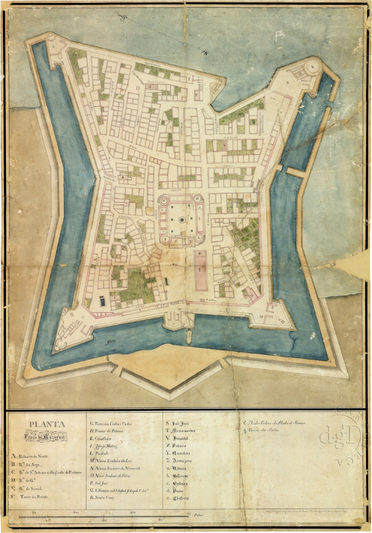 1720–1760 — Planta da praça de Mazagam [Material cartográfico] / feita pelo capitão-engenheiro Simão dos Santos, e desenhada por Guilherme Joaquim Pays — Direção-Geral do Território.
1727 — João Thomás Correa (BNP)
 1727 — Planta da Praça de Mazagão de João Thomás Correa, in “Livro de várias plantas deste Reino e de Castela, 1699–1743” — Biblioteca Nacional de Portugal.
1752 — Simão Correa de Mesquita (1751 clash)
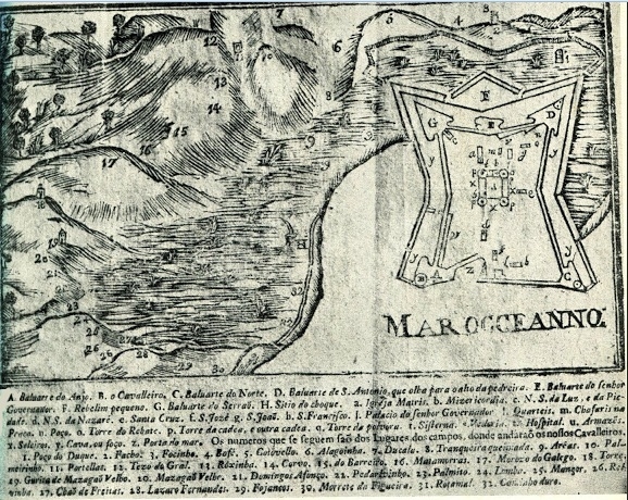 1752 — Planta de Simão Correa Mesquita, in “Relação do Choque que Tiveram os Cavaleiros da Praça de Mazagão com os Mouros de Aducala e Azamor em 7 de Dezembro de 1751” — Jozé da Sylva Natividade, Lisboa, 1752.
1757 — J. Bélicard (BnF)
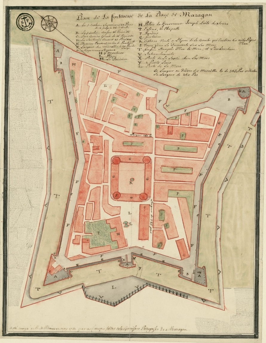 1757 — Planta de Mazagão de J. Bélicard — Bibliothèque nationale de France.
1769 — Siege dispositions (Casa de Ínsua)
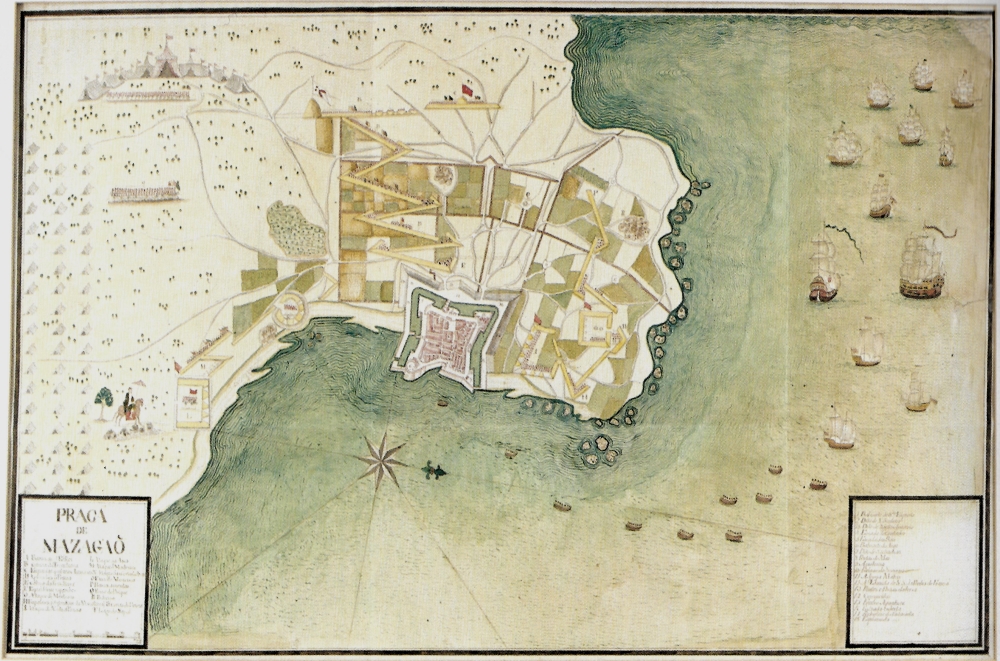 1769 — Disposição das tropas do Rei Sidi Mohamed no cerco a Mazagão de 1769 — Casa de Ínsua. The plan that shows the Moroccan army’s dispositions — the tribal camps stationed around the fortress to liberate it — on the eve of the final siege (same subject as our Figure 4 Praça de Mazagão).
1802 — Ignacio António da Silva (BNP)
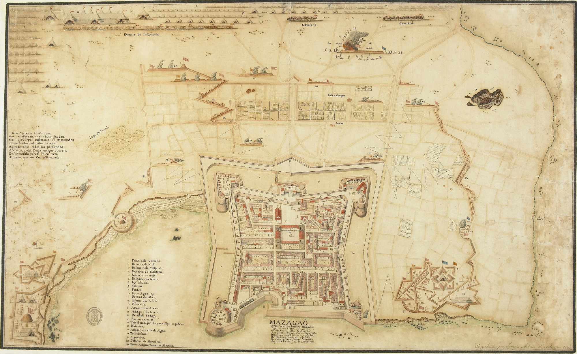 1802 — Planta de Mazagão desenhada por Ignacio António da Silva — Biblioteca Nacional de Portugal (also reproduced as our Fig. 11 in the bastion-details section).
1814 — Siege configuration (Gabinete de Engenharia Militar)
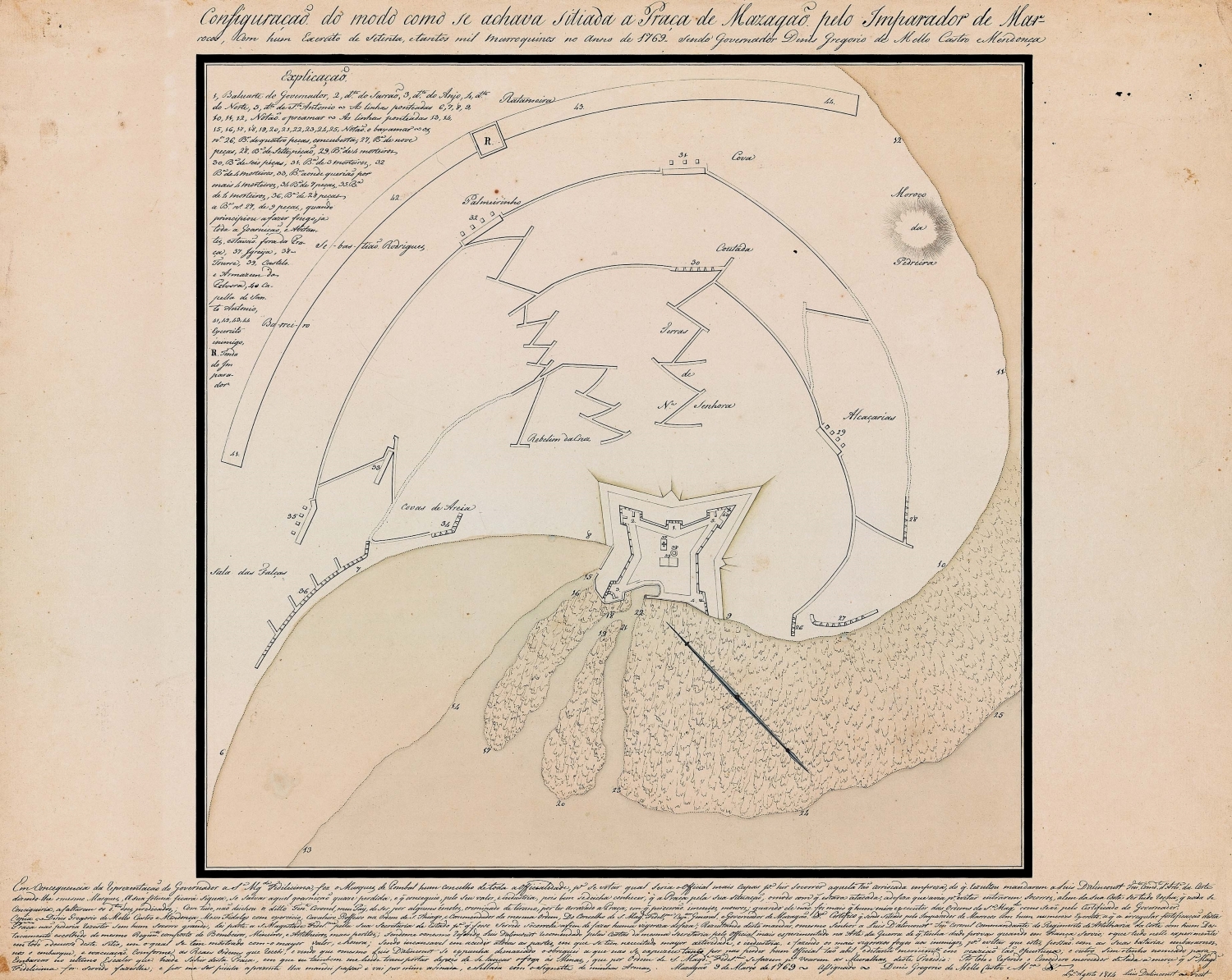 1814 — Configuração do modo como se achava sitiada a Praça de Mazagão pelo Imperador de Marrocos, Autor desconhecido — Gabinete de Estudos Arqueológicos da Engenharia Militar.
1737 & undated — Harbour soundings (BnF)
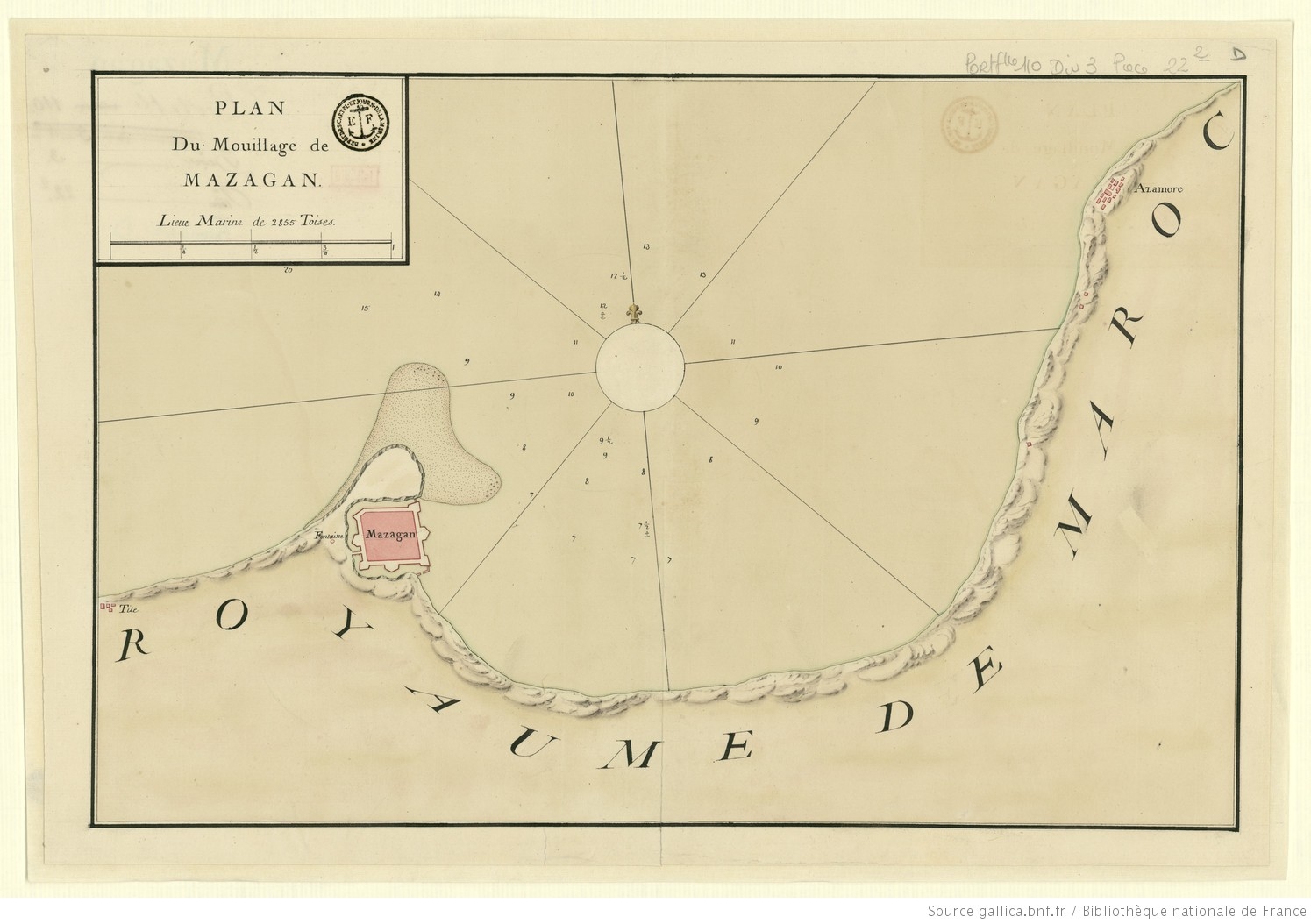 Undated — PLAN DU MOUILLAGE DE MAZAGAN — Bibliothèque nationale de France.
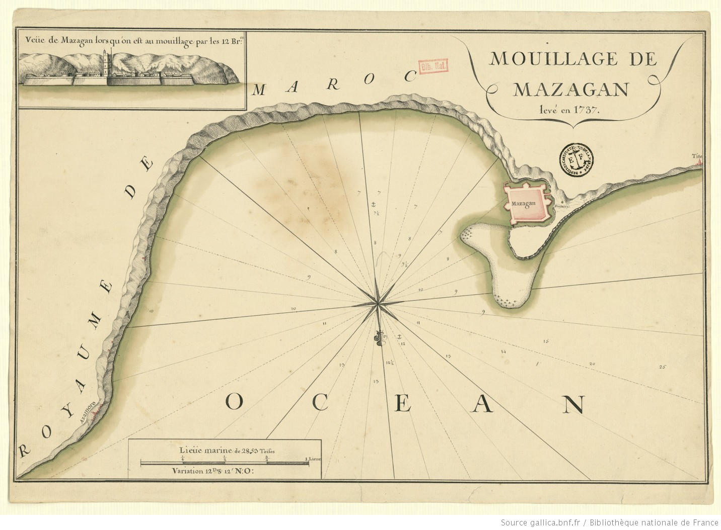 Mouillage de Mazagan — Levé en 1737 — Bibliothèque nationale de France.
1916 — French Protectorate town extension (BnF)
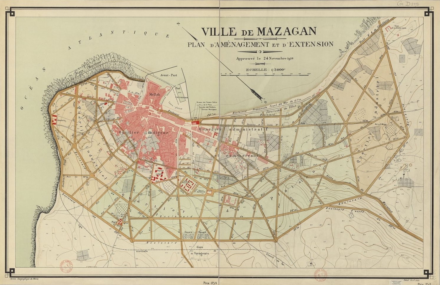 1916 — Ville de Mazagan. Plan d’aménagement et d’extension approuvé le 24 novembre 1916 — Bibliothèque nationale de France.
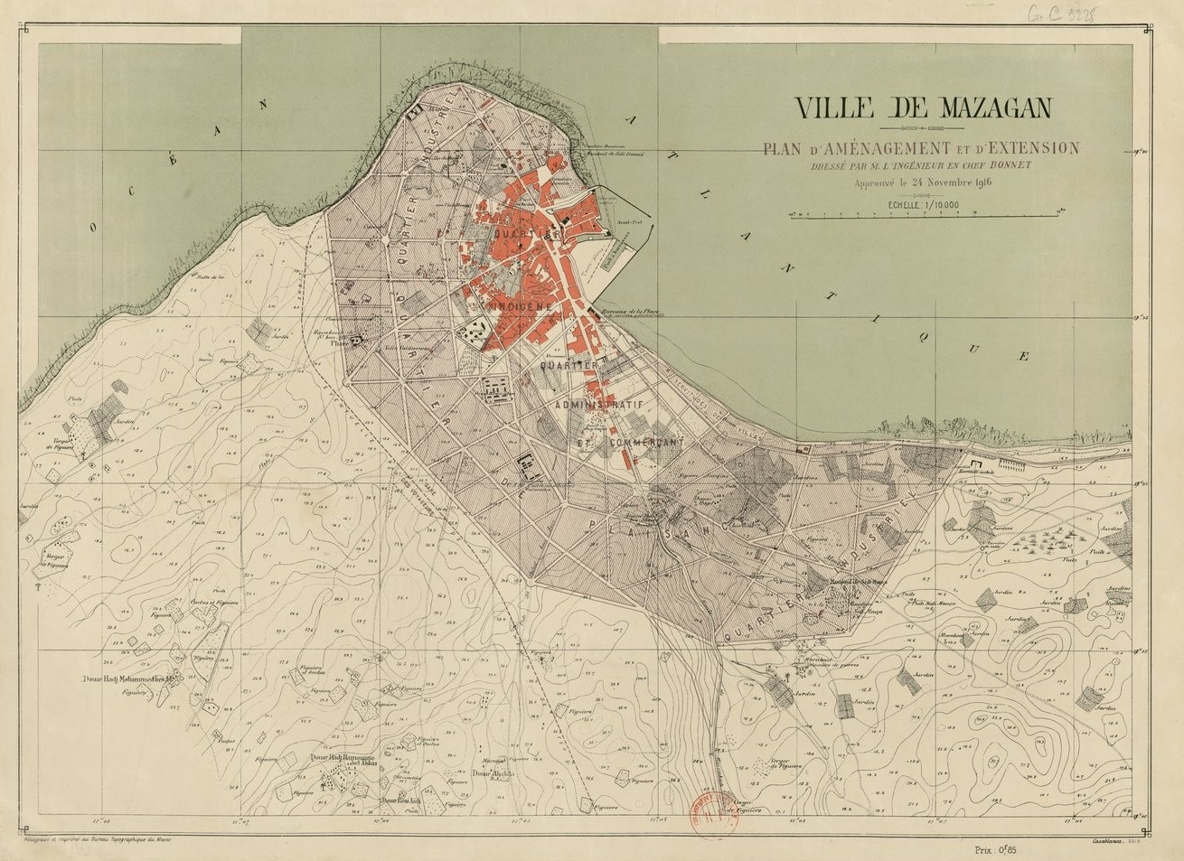 1916 — Ville de Mazagan. Plan d’aménagement et d’extension dressé par M. l’ingénieur en chef Bonnet, approuvé le 24 novembre 1916 — Bibliothèque nationale de France.
All scans via Histórias de Portugal em Marrocos; originals remain public domain (17th–early 20th century). See https://historiasdeportugalemarrocos.com/mazagao/ for the blog’s full captions and archival references.
Gates — arches, bridges and antechambers
All gates are round Roman arches in brick with limestone quoins and voussoirs, set within the 10–12 m thick curtain and flanked by embrasures. Clear openings are consistently ~3.0–3.5 m wide × ~4.0–4.5 m high to the arch crown, with a 1.5 m deep vaulted passage through the wall thickness and an antechamber (alpendre) ~4 × 5 m behind the arch defended by two embrasures.
| Gate (key on 1611 legend) | Position & Orientation | Structural type | Bridge / Access |
|---|---|---|---|
| Sea Gate (Porta da Ribeira / da Mar, L) | NE curtain, east-facing, opening to the calheta harbour | Single arch in NE curtain between Angel bastion and the mole (M); adjacent Escada da Calheta (O) — horse ramp to the harbour. | No bridge — opens directly onto the mole and the inner harbour basin (~40×40 m) |
| Bull Gate (Porta dos Bois, G) | NW curtain | Brick arch with limestone dressings; Escada dos Bois (H) stair immediately inside. Built to evacuate ditch spoil during construction; walled up for the 1562 siege, reopened 20th c. | Small timber bridge over a secondary ditch cut, later filled |
| Main Town Gate (Porta da Vila / Principal, A) | Centre of south (land) curtain, south-facing, inside the Governor’s Bastion gorge | Double arch — two parallel vaults each ~3.2 m wide with a central pier ~1.2 m, total gatehouse ~8 m wide × 4.5 m high; vaulted passage ~10 m deep through the bastion mass. Escada (V) ascends to the bastion platform. | Timber drawbridge (Ponte, E) ~6 m leaf spanning a 6 m gap, counterbalanced, with a triangular earthen ravelin (P, Primeiro Revelim) and covered way (Q) beyond; destroyed 1769 |
| Traitor’s Gate (Porta da Traição, D) | West curtain, beside St Antoine bastion | Well-preserved limestone Roman arch, antechamber ~5×4 m with two flank embrasures. | Small fixed stone bridge ~4 m over the ditch |
| Stream / Calheta Gate (Porta da Calheta) | Sea front near the small bay | Limestone Roman arch with small antechamber; the only sea gate used when the harbour mouth was blocked. | Direct onto foreshore |
Each gate threshold is at +2.5–3.0 m above ditch bottom; leaves were timber, studded and sheathed, hinged on limestone pintles still visible on Traitor’s Gate.
 Figure 11 — Sea Gate. (Add image here.)
 Figure 12 — Main entrance, ravelin, and drawbridge. (Add image here.)
 Figure 13 — Traitor’s Gate. (Add image here.)
The Moat (Cava) & Harbour (Calheta)
- Ditch (cava): a continuous ditch ~20 m wide × 3 m deep, cut into the coastal limestone and backed by the scarp wall. It runs on the south, west and north; the east side is open to the sea via the harbour gap. The outer lip carries the estrada coberta (Q), the inner lip the wall foot.
- Wet system: formerly filled with seawater, renewed at high tide and retained at low tide by paired gated culverts — the buxas (keys S,T) set through the wall near the Angel bastion and the Santo Espírito bastion. At high water the buxas opened; at ebb they closed, holding ~2 m of water in the ditch. Dikes at the harbour mouth regulated the calheta level.
- Harbour (calheta): a rectangular tidal basin ~40 × 40 m formed by the discontinuity in the sea curtain and closed on its seaward side by two moles (M,R) extending from the curtain and the Angel bastion. The basin is reached via Porta da Ribeira (L) and the horse ramp Escada da Calheta (O). At low tide the basin dries to expose currais/pesqueiras stone fish traps on the foreshore.
- Afterlife: during the French Protectorate (1912–1956) the ditch was filled with earth, a new gate was cut into the filled section opening onto Rua da Carreira toward the Sea Gate, and the Praia Mar de águas vivas (X) and sorgidouro dos navios grandes (Z, outer anchorage) became urbanized. Today a 50 m non-aedificandi zone protects the former ditch trace.
 Figure 14 — The moat’s former trace, now filled, around the land front. The 20 m width is still readable in the glacis.
Measured Street & Square Reference
| Element | Width / Size |
|---|---|
| Rua da Carreira (spine) | ~8–10 m wide, ~180 m long from Porta da Vila to Porta da Ribeira |
| Rua Direita (cross) | ~6–7 m wide, ~120 m long |
| Terreiro (square by entrance) | ~35 × 45 m, bordered by Palácio dos Governadores and Matriz |
| Arrabalde NW organic lanes | 3–4 m wide, irregular |
| Building height limit | ≤ 8 m (wall height) — no roof exceeds the parapet, preserving the global view from the chemin de ronde |
Interior Monuments
The Citadel as Urban Core & the Manueline Cistern
The 1514 Castelo Real de São Jorge (47 × 56 m) was not demolished — it was entirely remodelled and integrated as the central building of the new Cidadela, forming its urban and administrative heart. Around it clustered the chief buildings of the colonial town: Hospital da Misericórdia, Vedoria (purveyance), Cadeia (jail) and several Celeiros (granaries). In the old Praça d’Armas of the castle, excavated and vaulted over, lies the famous Cisterna Manuelina:
- Plan: ~47 m × 56 m, with three halls on the north, east, and south sides and four round towers:
- Torre da Cadea (of the prison) — west
- Torre de Rebate — north (later the base of the mosque’s minaret)
- Tower of the Storks — east
- Ancient Arab tower of El-Brija — south (the original pre-Portuguese watchtower)
- Central hall: 33 m × 34 m, partly underground, carried on 25 stone pillars (~0.8 m diameter, square capitals) in a 5×5 grid supporting brick rib vaults in the Manueline manner (late Gothic of King Manuel I, 1495–1521); vault crowns ~4.5 m above floor, floor is flagstone with a slight fall to a central drain. Initially fed by a cano (conduit) from a well outside the castle, then by channels gathering runoff from across the citadel.
- Capacity: 2,500 cubic metres, finished in November 1547 according to Governor Luís de Loureiro’s letter to the King (Les Sources 1951, IV:231).
- Design attributed to João Castilho, conceived c. 1547.
 Figure 15 — Cistern plan. (Add plan here.)
 Figure 16 — Cistern interior, Manueline vaults on stone pillars. (Add image here.)
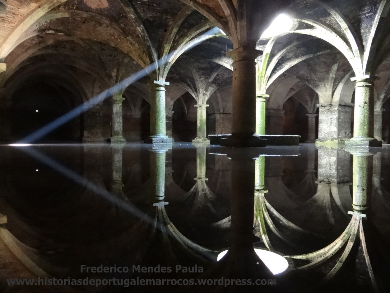 The Cisterna Manuelina — excavated from the old castle’s parade ground, 2,500 m³, Nov 1547. Histórias de Portugal em Marrocos (2025).
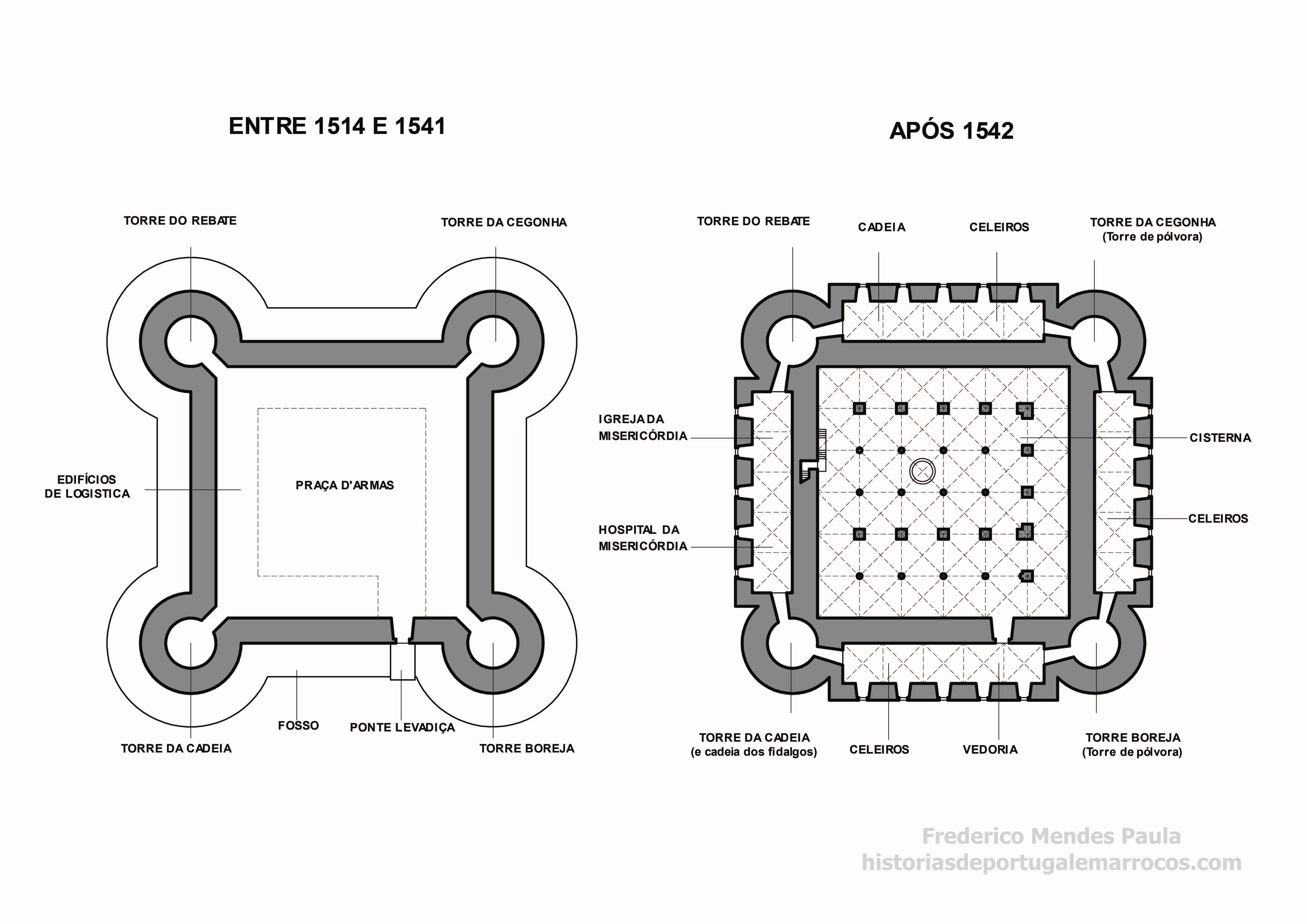 Transformation of the Castelo Real de São Jorge into the central building of the Cidadela (schematic). Histórias de Portugal em Marrocos (2025).
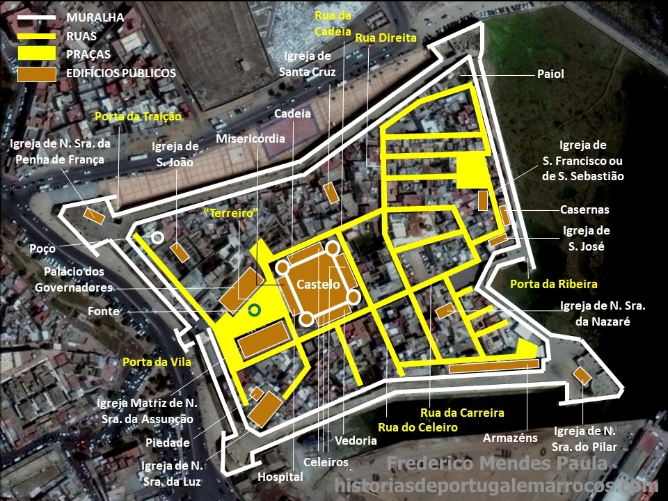
The First Ideal City outside Europe — streets & squares
Histórias de Portugal em Marrocos (2025) stresses that Mazagão was the first Renaissance “ideal city” built outside Europe, thought — in the author’s words — “to be impregnable and self-sufficient”, reconciling domestic urbanism and colonial urbanism through discipline, order and rationality with a military skeleton but all civil equipment required for 2,000–3,000 inhabitants.
- Two structuring axes (per the 2025 study):
- Rua da Carreira — the spine, running Porta da Vila (town gate, west) to Porta da Ribeira (sea gate, at the Calheta). Lined today by the best-preserved buildings (cistern, Matriz).
- Rua Direita — the commercial cross street, perpendicular to the Carreira.
- Terreiro — the main square by the entrance, stage for official ceremonies, bordered by the Palácio dos Governadores and the Igreja Matriz de Nossa Senhora da Assunção.
- Northwest organic trace — a surviving irregular street pattern that corresponds to the old spontaneous arrabalde of the Castelo Real.
Urban structure of Mazagão: the two axes (Rua da Carreira and Rua Direita) and the Terreiro. Histórias de Portugal em Marrocos (2025).
Church, chapels, and the life of the Mazaganistas
Mazagão counted 10 churches and hermitages besides the logistics buildings (Les Sources/2025 study). Beyond the Matriz de Nossa Senhora da Assunção (44 × 12 m, single nave, choir, sacristy) we find São Francisco (or São Sebastião), São José, Nossa Senhora da Nazaré, Nossa Senhora do Pilar, Nossa Senhora da Luz, Nossa Senhora da Piedade, Nossa Senhora da Penha de França, São João and Santa Cruz.
A strict rule — no building could rise above the wall height — ensured that from the caminho de ronda a global view of the interior was always preserved and that an outsider could never read the town’s structure or locate its chief equipments. For that reason the Matriz originally had no bell tower (the present tower is early-20th century).
Population divided into fronteiros (military and royal officials on 5-year commissions), moradores — the Mazaganistas, who remained for generations, degredados (exiles serving reduced sentences) — often the only ones who would risk working outside the walls — and non-Portuguese communities (Arabs, Berbers, Jews and merchants of various nations, above all Italians). Histórias de Portugal em Marrocos (2025) collates: 2,000–3,000 inhabitants forecast in 1541; 700 fogos (households) in 1615 (Gov. D. Jorge de Mascarenhas); 500 fogos in 1625 (Gov. D. Gonçalo Coutinho); 2,092 persons in 425 families in mid-18th-century registers. Two plans — Simão dos Santos / Guilherme Joaquim Pays (1720–1760, DGT) and J. Bélicard (1757, BnF) — remain the richest sources for building-by-building use.
Festivals tightened community bonds: religious processions reaching 15 days, above all those celebrating the ransom of captives — who paraded with chains and shackles with instruments of torture on display — and martial games: carreiras, torneios, the game of argolinhas (lancers threading rings on cords in Rua da Carreira), and the popular cavalhadas — battles of scented clay balls (alcanzias, from Arabic al-kanzía, treasure), hollow sun-dried clay spheres filled with flowers and painted ribbons.
Church of Our Lady of the Assumption
- 16th-century parish church, rectangular plan 44 m × 12 m, a single nave, choir, sacristy, and a square bell tower (tower added only in the early 20th century; originally wall-height compliant).
- Built in the Manueline / late Gothic style — one of the two key Portuguese monuments (with the cistern) cited by UNESCO.
 Figure 17 — Church of the Assumption (originally without tower). (Add image here.)
Streets & Urban Plan — legacy
- The 1541 town grid derived from subdividing the central citadel square into regular rectangular blocks.
- Rua da Carreira — preserved as the main street; Praça Terreiro — the square toward the entrance, delimited today by the 19th-century mosque whose minaret reuses the old Torre de Rebate.
- Other ensembles: chapel of St Sebastian (in its bastion), Misericórdia (only its bell tower remains), and later a Spanish church, synagogues, and the mosque.
 Figure 18 — Rua da Carreira. (Add image here.)
 Figure 19 — Praça Terreiro. (Add image here.)
The Outer Field (Campo Exterior) — 38 hectares outside the walls
Mazagan could not live cut off from the land. Besides maritime supply, the garrison daily needed firewood, precarious agriculture and pasture. For that the Portuguese organized a rational, militarized outer field that allowed them to farm and graze without permanently occupying territory — described in depth in “Mazagão, de Castelo a Cidadela” (2025) and the blog’s “O Campo Exterior das Praças de Marrocos.”
-
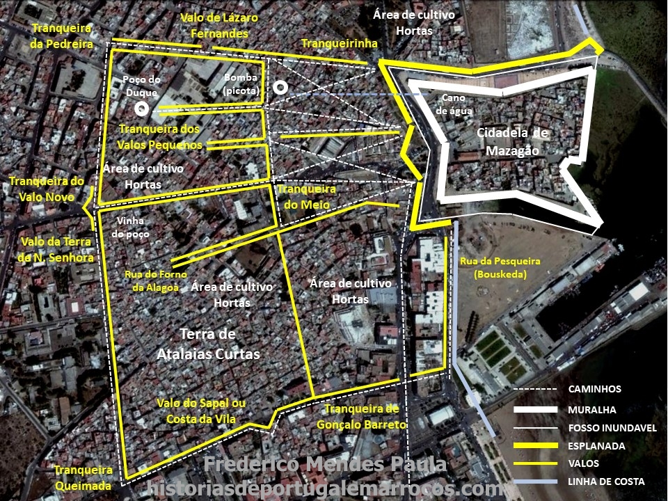
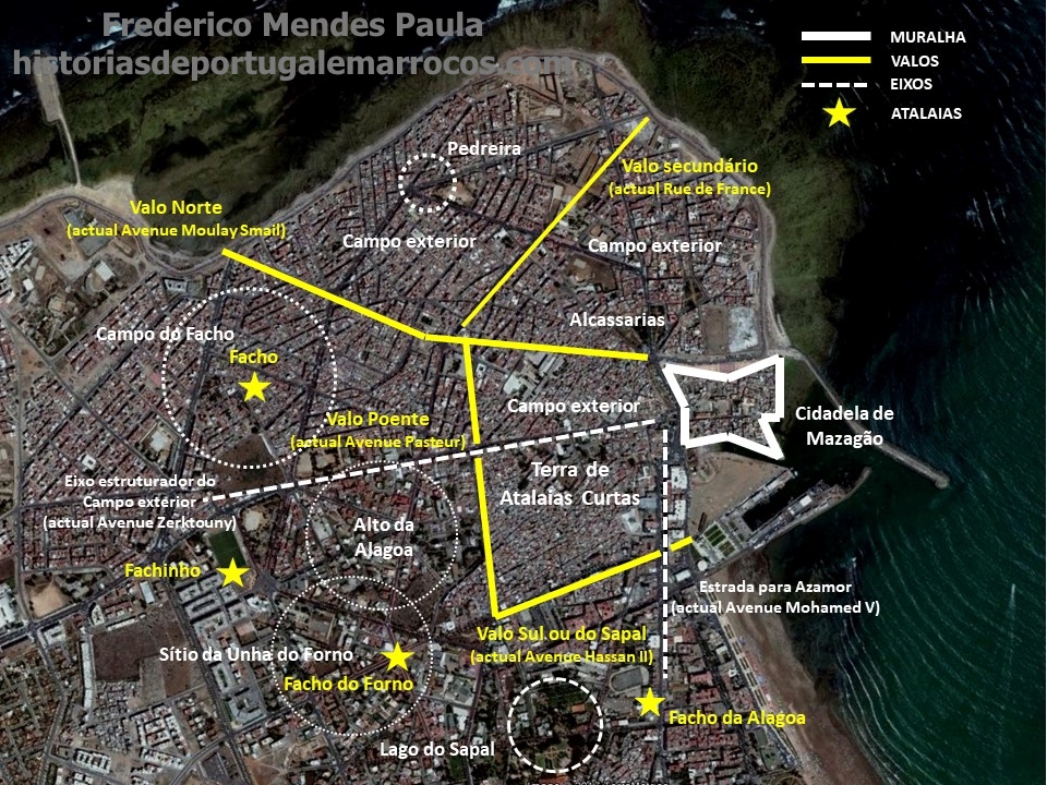
Campo Exterior Consolidado — 38 hectares, perimeter 2,250 m, extending about 600 m inland. Enclosed and structured by valos (loose-stone walls ~1.7 m high) that formed barricaded lanes (mangas) gated by tranqueiras (stockades); entrances protected by earthen revelins. The field was divided into well-delimited talhões of regular trace, kept under continuous surveillance including night sorties — some moradores even slept outside to guard harvests. Its structuring began during the Cidadela’s own construction to protect the quarry-to-site stone haul. Lopo de Pina to D. João III: “Luís de Loureiro, captain, orders me to pay for certain valos he has outside this town for security of its field” (Les Sources 1951, IV:15). By 1621 the King ordered many interior quintas and walled gardens demolished — “close to the walls … where Moors, when they harry the fortress, shelter … so that revelins may fulfill their defense mission” (Farinha 1970:50–51, quoted in 2025).
-
Terra das Atalaias Curtas (Terra dos Fachos) and Terra das Atalaias Longas — vigil zones defined by fachos/atalaias (watchtowers on hillocks). Daily routine: at dawn escutas / atalhadores / monteiros swept the field for infiltrators hidden overnight; then atalaias took hilltops with costas (guards at the hill foot); if secure, the facheiro hoisted a cloth-lined basket on a mast at the Facho, the signal received at the Torre de Rebate where the governor ordered five bell tolls to start work. On danger the facho was lowered and evacuation ordered by cannon shots; everyone rushed inside and the gate shut. The 17th-century French apothecary Jean Mocquet witnessed it: “Every morning about 40 horse go out from Mazagan to discover the field and remain there till midday; and after that hour another 40 go out … Six of them, called atalaias, take post at distant stations … on each station a great wooden mast with a kind of flag hoisted by rope — the warning for dwellers to arm” (Mocquet 1617:56). Degredados commonly served as atalaias/batedores because the work was dangerous but well paid. D. Gonçalo Coutinho (1629:4) boasted: “The field is, without contradiction, the clearest of our frontiers, and so secure, after being discovered, that, without unruly men who wish to break through the atalaias, women and children may enjoy it without any danger.” The Simão Correa Mesquita plan of 1752 uniquely shows the Terra das Atalaias Longas stretching to Mazagão-Velho (near the present motorway tolls).
This consolidated + atalaia system was complemented by an offensive, preventive arm — the almogávares / Estuques, elite cavalry that raided neighbouring villages to keep inhabitants distant and plunder goods. Robert Ricard (1933:448–449) directly links this “segurar o campo” technique to the longevity of Ceuta, Tangier and Mazagão — allowing supply in water, wood and forage “without properly occupying territory, and consequently without the military and financial effort that proper occupation implies.”
 The Consolidated Outer Field: 38 ha divided into talhões. Histórias de Portugal em Marrocos (2025).
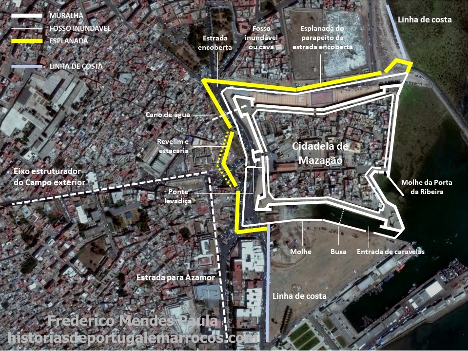 Close defenses: the ditch, the road around it, and the earthen esplanade forming two revelins — one shielding the Porta da Vila. Histórias de Portugal em Marrocos, “Os Mazaganistas” (2017).
 The valos-enclosed area of the Outer Field, called Terra das Atalaias Curtas. “Os Mazaganistas” (2017).
 Superposition of the Outer Field’s talhões onto the modern street grid of El Jadida — searching for surviving traces. “Os Mazaganistas” (2017).
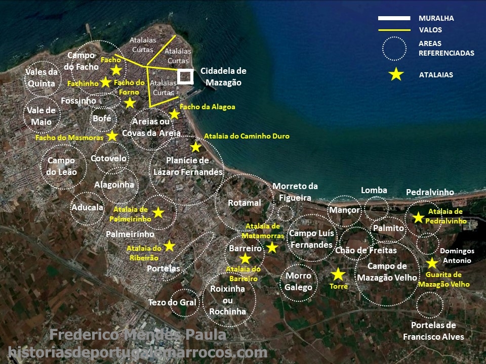 The atalaias of Mazagão with plains, hills and valleys along Haouzia beach — the Long watch zone stretching toward Mazagão-Velho near the present motorway tolls. “Os Mazaganistas” (2017) after the 1752 Mesquita plan.
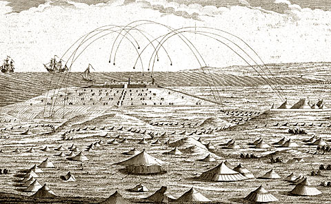 Le siège de Mazagan, 1781 engraving, unknown author — a non-duplicated siege view. “Os Mazaganistas” (2017).
Society within the Walls — the Mazaganistas
“Não havia espaço que não estivesse cheio de recordações: uma pedra, a esquina de uma rua, um largo. Os Mazaganistas formavam um corpo com seus muros. Defendê-los era a sua razão de viver e de esperar. Muitos deles não imaginavam qualquer destino fora dos muros da fortaleza.” — VIDAL ([2005] 2008, p.51), quoted in “Os Mazaganistas” (2017)
Mazagão held four or five generations isolated on half a dozen hectares, in permanent alert and scarcity. That isolation forged a resilient, warlike community with its own subterfuges against boredom and anxiety — the Mazaganistas.
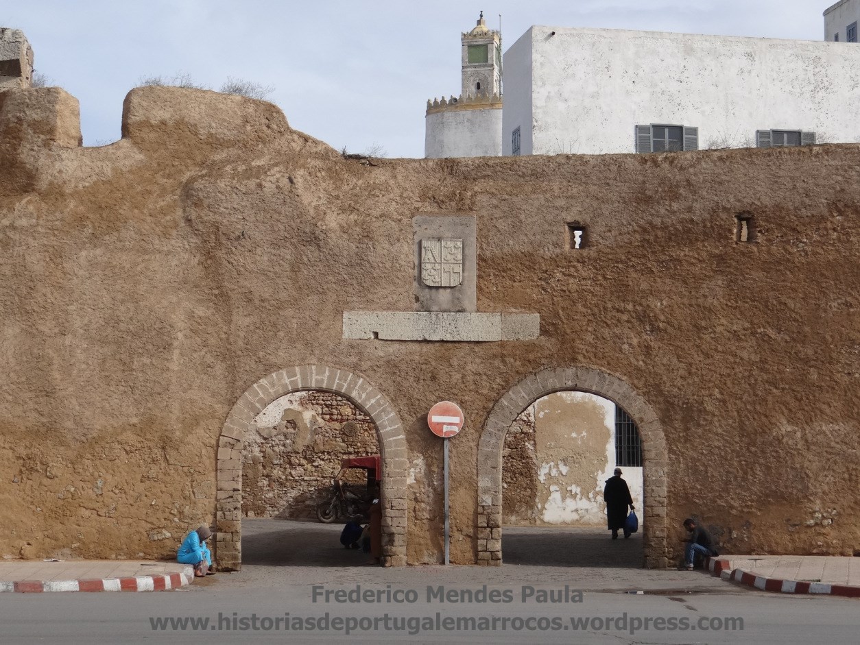 Porta da Vila of the Cidadela. “Os Mazaganistas” (2017).
Two peoples, one wall — fronteiros and moradores
The population fell into two great groups, plus a penumbra of minorities:
-
Fronteiros — temporary “frontier” personnel, generally three to four years (earlier summaries gave five), mostly military but also royal administrators, paid in tença (money) and resguardo (food). They sought rapid ascent and easy enrichment through plunder and even diversion of royal stores, often bringing family, servants and retainers. Noble, often young and single, their frictions with moradores’ daughters were a constant tension.
-
Moradores — the fixed population, truly constituted only from the 17th century (before, only fronteiros and kin occupied the square). Many came from the Azores, above all São Miguel. These are the Mazaganistas proper, who practiced the vital professions generation after generation and gave the community its identity. João de Figuerôa-Rego (2007:58) rejects the neat dichotomy as artificial — moradores also enjoyed Crown benefits, “holders of the foro of knight-fidalgo, in some cases cumulated with the habit of Christ,” though serving longer and with lesser mercês; nobre and plebe coexisted in both groups.
-
Others — clergy, degredados expiating crimes (often the only ones willing to work risky outer-field jobs), slaves, merchants — many Jews, English, Danish, Dutch or Genoese — and local Arab and Berber minorities.
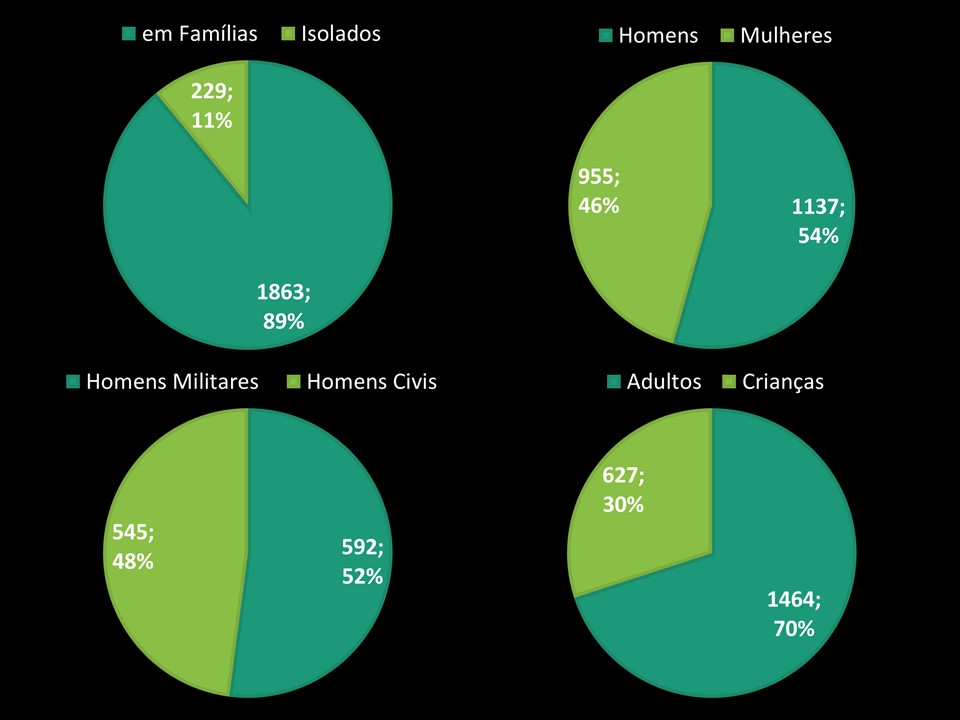 Population profile of the Mazaganistas evacuated 11 March 1769, from the Relação das Famílias (Azevedo e Silva).
How many? — 700 fogos to 3,000 souls
Histórias de Portugal em Marrocos (2017, 2025) collates:
-
2,000–3,000 forecast in 1541 (foundation estimate);
-
700 fogos (households) in 1615 — Gov. D. Jorge de Mascarenhas;
-
500 fogos in 1625 — Gov. D. Gonçalo Coutinho;
-
Simão Correia Mesquita (1751:7): 150 cavalry and 400 infantry in the garrison;
-
Pedro da Silva Correia (1763:4): when complete, 600 infantry, 200 horse and 40 gunners; “more than three thousand persons of both sexes of the Portuguese nation live in this square, among them a great multitude of Knights of the Order of Christ and Fidalgos of His Majesty’s House; the majority are of old families and noble progenies”;
-
1769 evacuation: Crown’s Relação das Famílias que vieram da Praça de Mazagão em 11 de Março de 1769 (used to organize transfer to Amazonia) lists 2,092 Portuguese evacuees in 425 families (average 4 persons), analysed by José Manuel Azevedo e Silva. Their profile is surprisingly balanced despite military weight: 54 % male / 46 % female, 89 % living in families, 30 % children to age 10. But — as “Os Mazaganistas” stresses — this covers only Portuguese evacuees; “about the 3,000 inhabitants Correia speaks of, only 2,092 are in this list. Outside remain many individuals such as Arabs, Berbers, mouriscos expelled from Portugal and Jews, and certainly also fronteiros, degredados and others in transit, whose inclusion would drastically alter the social profile.” Excluded groups, plus the fact “family” meant any sharing a hearth — “father and daughter, mother and son, priest and maid, widow and slave, uncles, nephews, grandparents, in-laws, godchildren, stepchildren, foundlings, agregados” (Silva 2004:174) — explains both the balance and its limits. Wealth was uneven: some families lived “faustosamente,” most modestly, some in great need.
-
Garrison at evacuation: 592 men — 472 infantry, 99 cavalry, 21 artillery, including facheiros, atalhadores and atalaias of the outer field. Silva (2004:173) notes its reduction betrays that “the option to evacuate had already been weighed by the Josefina cabinet for some six years.”
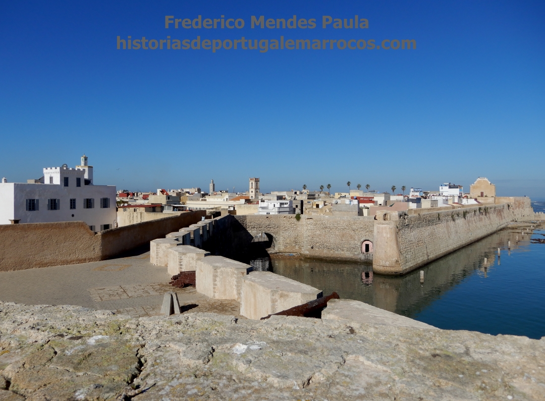 The Cidadela seen from the eastern mole — the 592 at evacuation in March 1769. “Os Mazaganistas” (2017).
Professions and institutions
- Administration first by the governor / captain (military character), then alcaides, judges, porteiros, alfaqueques (captive-ransomers), tabelião (notary), escrivães da vedoria and do almoxarifado, fiel dos armazéns and the piloto da barra (harbour pilot).
- Military in three corps (1769): 472 infantry, 99 cavalry, 21 artillery, with condestáveis, almocadéns, anadéis, captains, lieutenants, alferes, sergeants, artilheiros, atalaias, atalhadores, soldiers and knights — and outside, the facheiros and atalaias.
- Beyond the clergy: médico, cirurgião, boticário, mestre de meninos, plus indispensable trades — pedreiros, carpinteiros, shipwrights, bakers, butchers, tailors, farriers, smiths, rope-makers, artisans, farmers, fishermen and herdsmen.
- Support institutions: the Misericórdia with its Hospital and Albergue for the poor and strangers, and the Confraria da Piedade plus other mutualist and corporative brotherhoods.
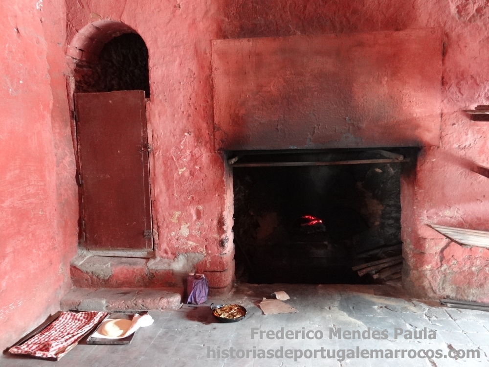 Communal oven in Mazagão — one of the vital trades inside the walls. “Os Mazaganistas” (2017).
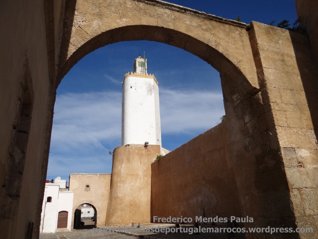 Torre do Rebate, now the mosque’s minaret — the signal tower for the outer field. “Os Mazaganistas” (2017).
Strangers in the fortress
Arabs and Berbers lived under strict control, usually outside the walls trading cattle and farm produce, feared for treason. Mouriscos arrived from Iberia after expulsion, in transit before dispersal inland; sincere converts served in the almogávares or outer field. Foreign merchants on temporary stay generally slept aboard ships anchored in the ditch. Jews controlled commerce — and earned commissions on foreign trade — playing a double role as intermediaries with Moroccan authorities; those resident obeyed a rigorous discipline and temporary authorizations. The Bishop of Ceuta’s 1607–1609 statutes (Farinha 1970:78–79, cited in “Os Mazaganistas”) imposed: arrivals in a caravan left with the next, night in a closed zone, holy days confined, no windows open on Friday, retreat during Christian ceremonies, blue hats or caps, no street vending except Mondays and Thursdays, synagogue only by royal licence, Christians forbidden to attend or collaborate in their ceremonies, gamble with them, enter their houses, keep books contrary to the Christian religion — frequent searches, must speak Portuguese or Spanish, cannot testify in courts, among others.
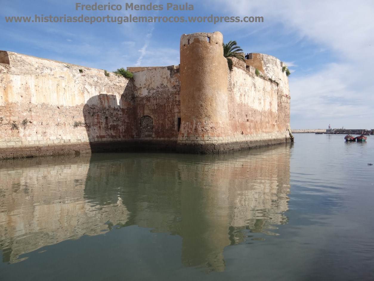 Baluarte do Anjo seen today — the sea bastion that sheltered the harbour. “Os Mazaganistas” (2017).
Daily life under siege — boredom, tension and festa
Mid-18th-century life was, per Laurent Vidal ([2005] 2008:12), at the limit of the tolerable: “envy, greed, rumour, slander and insubordination become the banality of an unbearable quotidian.” The monotony, confinement, waiting and uncertainty were punctuated by rigorous discipline — and by regular festivals staged deliberately to strengthen bonds:
- Governor-promoted celebrations e.g. Anniversary of King D. Pedro II in 1677: “On the eve … His Lordship the Governor had luminárias made. And on the day in the morning mass and preaching, artillery and musketry loads; in the afternoon took possession of a company … with all brilliance and grandeur, splendid banquets for all. In the same afternoon with gathering of the field inward, there were horse festivals with all bizarria” (Cosme 2003:90–91, Códice 296, quoted 2017).
- Crown-promoted nationals e.g. Marriage of Princess D. Maria (1760) and birth of Prince D. José (1761).
- Religious calendars: processions or holy days reaching 15 days, above all those celebrating the ransom of captives parading with chains and shackles plus instruments of torture.
“Também aqui se fazem os ofícios divinos pela Quaresma mui bem … Em quinta-feira de Endoenças houve lava-pés com toda a majestade porque serviu um Governador a outro … na noite houve procissão na Misericórdia das bandeiras … Em dia de São João montou o Senhor Governador a cavalo pela madrugada com toda a cavalaria … a metade ao nosso uso e a metade à mourisca que era bem vistosa coisa. Foram aos revelins dela, onde houve muitas escaramuças e carreiras como todos os anos é estilo” (Cosme 2003:91, Códice 296).
Games were martial in flavour: carreiras, torneios, argolinhas (in Rua da Carreira, lancers threading rings on cords), and the beloved cavalhadas — mock wars of alcanzias (from Arabic al-kanzía, treasure): hollow sun-dried clay balls filled with flowers and painted ribbons. Rivalries flared especially between fronteiros (noble, transient, often young and single) and moradores’ daughters of humble condition — a source of envy and conflict alongside status jealousies.
Occasional commerce with neighbouring Gharbia and Xarquia tribes (“mouros ladrões”) punctuated hostility — in famines the Mazaganistas bought women and children as slaves, horses, cattle and wheat (and sold). More formal was the 1677 visit of the Alcaide of Azamor: at seven in the morning the field was peopled with atalaias, toward eight-nine a signal of Moors — charges of goods and cattle sent ahead by the alcaide as gift to the Governor, accompanied by his servants, two Moors of respect and a Jew as interpreter, many foot muleteers “ridiculous subjects.” The Governor received them with joy and distributed a ram to each officer and the rest to the butcher for the populace, hides given as alms to Nossa Senhora da Penha de França (Cosme 2003:93, Códice 296). Both sides exchanged hostages outside the valos and a banquet in tents was held while “much cavalry and infantry with women and children” of the alcaide’s retinue waited.
Food — from biscuit to bouskeda
The staple was metropolitan imports — grain/flour/biscuit, dried meat or fish, oil and wine. Frescos depended on what could be grown or gathered:
-
Outside, when Moroccan raids allowed, they sowed wheat and barley, fava, vines, melons: “The moradores sow up to three hundred moios of barley and fava and make great melon patches and there are many gardens and more than twenty walled enclosures (serrados) called quintas, many with a thousand vines besides trellises and other trees and notable the grandeur this sustains in Barbary, guarding night and day with arms in hand for which men often sleep outside and at cost of many deaths and captivities to Moors who come to destroy them … the field is most fertile as much in herbs and wood as in game” (Farinha 1970:65, citing Belisário Pimenta). Simão Correia Mesquita one day found “the Poço do Duque whence the dwellers drink, surrounded, and the gardens destroyed by Moors; hostility with which they often challenge the garrison” (Mesquita 1751:10). A 1677 calm year: “Much hay was made because Moors did not burn it as they do every year … many times chinchorro nets were cast and gathered without alarm” (Cosme 2003:90).
-
When truce failed, reduced to wood, dates, forage, snails and fishing. Jean Mocquet (1617:57) notes snails were a staple; white honey from hives on rooftops; hunting lions, hares, partridges, boars and jackals; on foreshores and ditch clams, mussels, sea-urchins and lobsters. A rich piscary: “in the bay in summer they take tazartes and dogfish … on the coast great numbers of snapper (pargos), conger (safios) and hake … at low tide many currais (called pesqueiras) that are covered by sea and at ebb remain full of fish killed with trident … lavagantes, morays, pit conger … at baixa-mar great copy of limpets, sea-urchins and mussels of notable greatness” (Farinha 1970:66, citing Pimenta).
Mazagão’s ingenious pesqueira / bouskeda (or bouskira) fishing — still done at El Jadida and Casablanca — built meia-lua or straight low stone walls on the gently sloping foreshores (laredos) around the citadel, covered at high tide; the ebb is extremely rapid due to the slight incline, so fish remain trapped inside at low tide and are speared. Its Portuguese origin is transparent in the name. Inside the Outer Field a Rua da Pesqueira between valados still bears the name. Inside the walls they kept chickens and some livestock.
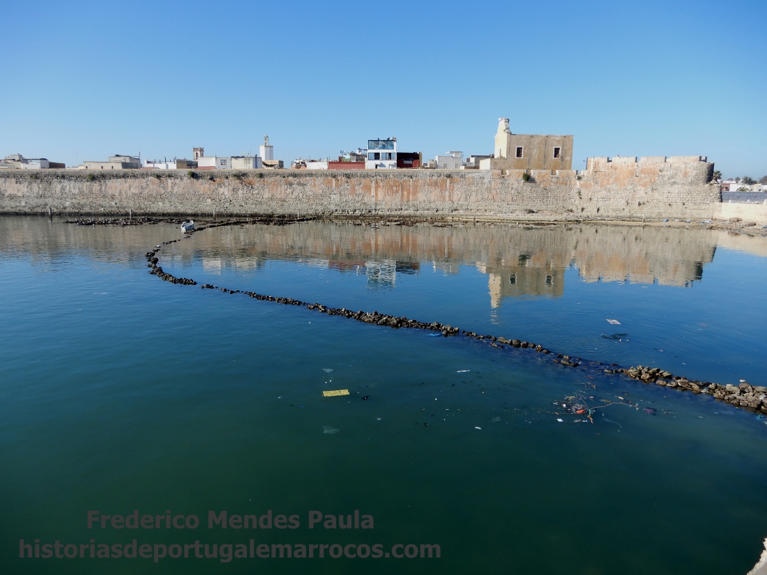 Stone bouskeda wall at low tide — meia-lua trap still used today at El Jadida. “Os Mazaganistas” (2017).
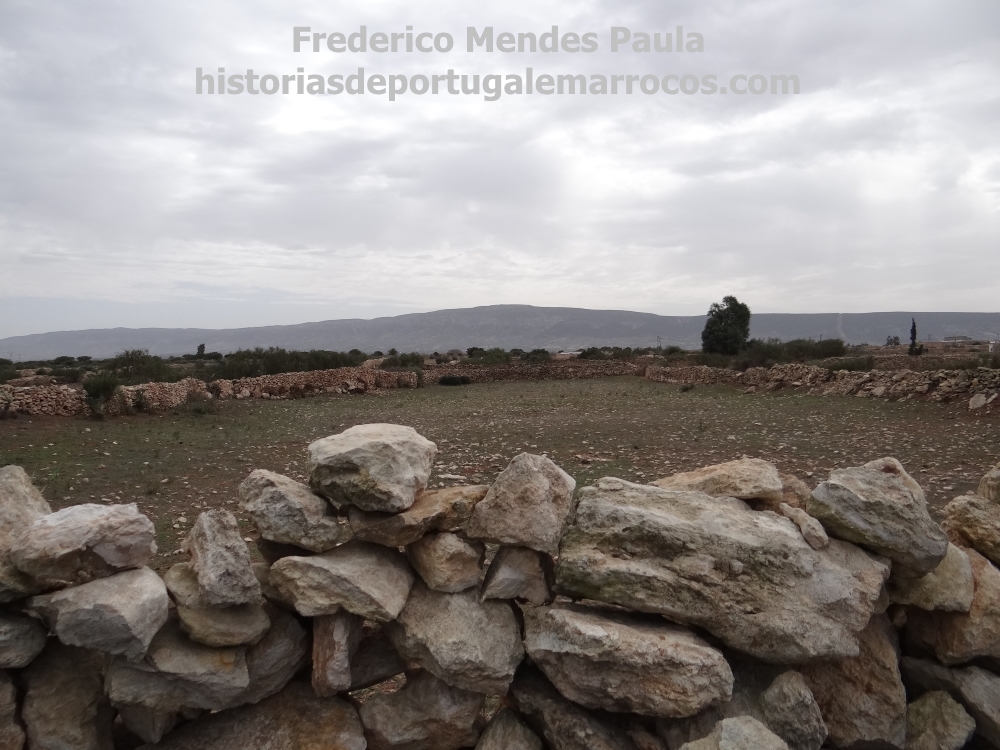 Valos or valados — loose-stone walls about 1.7 m high that structured the Outer Field. “Os Mazaganistas” (2017).
Military & Historical Significance
- Mazagan is one of the earliest realized examples of the Renaissance bastioned system (trace italienne), predating or matching many European fortifications and applied in a colonial context.
- Its design directly answered the rise of modern artillery: low, thick, battered walls; angled bastions to eliminate dead ground; orillons protecting flanks; a wet moat; and a grid town planned for control and logistics.
- It was the most durable of Portugal’s Moroccan holdings (1514–1769), outlasting Azemmour, Safi, Agadir, and (later) Tangier and Ceuta’s southern companions, making it the longest continuous European bastioned occupation on the Moroccan Atlantic coast.
- The 1769 transfer produced a remarkable urban transplantation: Nova Mazagão in Brazil replicated Mazagan’s plan, carrying Portuguese military-urban ideas across the Atlantic.
Related Entries
Events
- Siege of Mazagan 1562 — The Great Siege (to be created)
- Siege of Mazagan 1769 — The final siege and evacuation (to be created)
- Almoravid Conquest — Earlier Berber polities of the Moroccan interior
Realms
- Barghawata — Atlantic Morocco before the Portuguese era
Projects
- Deserted Tales I — the Omniversify stealth-action RPG set in Portuguese-occupied Mazagan (El Jadida)
Concepts
- Trace italienne / star fort — the Renaissance bastioned fortification system
- Manueline — the late-Gothic Portuguese style of the cistern and church
- al-Mahdouma — the “Ruined” name of the abandoned citadel
- Nova Mazagão — the Brazilian transplant of the city
Sources
- UNESCO World Heritage Centre, Portuguese City of Mazagan (El Jadida) — whc.unesco.org/en/list/1058/
- ICOMOS Advisory Body Evaluation, Mazagan (Morocco) No 1058 Rev (UNESCO archive)
- UNESCO, Mazagan (Morocco) — nomination/document 151641
- Archnet, Cidade portuguesa El Jadida, Morocco (archnet.org/sites/18535)
- HPIP — Mazagan (Morocco), heritage entry by Andre Figueiredo (hpip.org)
- Jorge Correia, Atlantic urban transfers in early modernity: Mazagão, from Africa to the Americas (2013)
- João Campos, The Mediterranean vanguard of Modern fortification: Benedetto da Ravenna and Portugal – Vila Viçosa and Mazagan (2017)
- João Campos, O modelo italianizante no sul de Portugal: o castelo de Vila Viçosa e Mazagan — source of Figs. 10–16 (plans & bastion details, incl. the Governor’s Bastion)
- Wikipedia: El Jadida, Siege of Mazagan (1562), Siege of Mazagan (1769)
- Wikipedia (illustration): “Defesa de Mazagão” by Alfredo Roque Gameiro, História de Portugal, Popular e Ilustrada, vol. 4 (Wikimedia Commons, public domain)
- Histórias de Portugal em Marrocos (Frederico Mendes Paula), Plantas de Mazagão — https://historiasdeportugalemarrocos.com/mazagao/ — gallery of ancient plans (1611 Codex Cadaval PT/TT/CCDV/29 Torre do Tombo; 1720–1760 Simão dos Santos / Guilherme Joaquim Pays DGT; 1727 João Thomás Correa BNP; 1752 Simão Correa Mesquita; 1757 J. Bélicard BnF; 1769 disposição das tropas Casa de Ínsua; 1802 Ignacio António da Silva BNP; 1814 Gabinete de Estudos Arqueológicos da Engenharia Militar; 1737 & undated Mouillage BnF; 1916 Ville de Mazagan BnF)
- Histórias de Portugal em Marrocos (Frederico Mendes Paula), Mazagão, de Castelo a Cidadela (4 Mar 2025) — https://historiasdeportugalemarrocos.com/2025/03/04/mazagao-de-castelo-a-cidadela/ — synthesis of the 1502 El Brija, 1514 Castelo Real (30 varas, 4 towers: Cadeia/Rebate/Cegonha/Boreja), Francisco Danzilho surveys, 1534 consultation & 1541 decision, Holanda/Benedetto/Arruda/Castilho/Torralva/Ribeiro team (Holanda brick, Castilho vs Torralva siting, Benedetto +1/3 toward sea, João III “mais metida na água” instruction, 5.5 ha 275×200 m 12 m wall, dikes/buxas, firing diagrams 600 m, July 1541 1,500 masons, Couraça Dec 1542), first ideal city, two axes Rua da Carreira/Rua Direita, 2,500 m³ cistern Nov 1547, 10 churches, population 700/500 fogos, Campo Exterior 38 ha 2,250 m with valos/tranqueiras, daily atalha routine, Mocquet & Coutinho witnesses, almogávares — primary source for the expanded Citadel, Urban and Outer Field sections above
- Histórias de Portugal em Marrocos (Frederico Mendes Paula), Os Mazaganistas (17 Jul 2017) — https://historiasdeportugalemarrocos.com/2017/07/17/os-mazaganistas/ — social history, defesas próximas/atalaias outer-field maps, population chart 1769 (2092 in 425 families, 54/46 % sex, 89 % in families, 30 % children), professions, institutions, daily diet and bouskeda fishing, Jewish statutes 1607–09, Vidal society quote — primary source for the Society within the Walls and enriched Outer Field sections above; plans via the blog include defesas próximas, campo valos, sobreposição El Jadida, atalaias along Haouzia, 1781 siege engraving
- Wikimedia Commons, File:Praça de Mazagão.jpg — 18th-century view of the fortress with tribal camps during the 1769 siege (public domain, via históriasdeportugalemarrocos.com; lead image on Siege of Mazagan 1769)
- Wikimedia Commons, File:Mahadúma Berisghia Mazagán.jpg — engraving by Peter Haas of the 1769 siege, in Georg Hjersing Høst, Efterretninger om Marokos og Fes (1779) (public domain, 1779, via archive.org)
- Encyclopaedia of Portuguese Expansion (EVE), CHAM – NOVA FCSH / UAc, Mazagan: Captains and Governors (1514–1769) (2009) — https://eve.fcsh.unl.pt/en/lists/mazagan-captains-and-governors-1514-1769 (CC BY 4.0)
- Moorish Times, From Mazagan to the Present: The History of the City of El Jadida